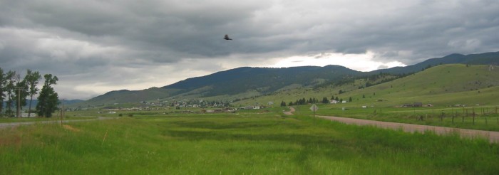
At Top Center Of Photo: A Red-Winged Blackbird Comes Close To Cry Alarm.
.And Chase Me Away. This I Do Quickly After This Photo Is Taken.
.Ahead Are Seen The Houses Of Philipsburg, MT.
.
. and are off into valley meadows.
Valley of Philipsburg, MT. As you can see in the photos, the narrator again accurately captures the change in scenery. And like the narrator, I experienced strong wind here!
..****************..
Concerning The Clark Fork River, Wikipedia Says:
.The Clark Fork, or the Clark Fork [River] of the Columbia River, is a river in the U.S. states of Montana and Idaho, approximately 310 miles (500 km) long. The largest river by volume in Montana, it drains an extensive region of the Rocky Mountain
.The river flows northwest through a long valley at the base of the Cabinet Mountains and empties into Lake Pend Oreille in the Idaho Panhandle. The Pend Oreille River in Idaho, Washington, and British Columbia, Canada which drains the lake to the Columbia in Washington, is sometimes included as part of the Clark Fork, giving it a total length of 479 miles (771 km), with a drainage area of 25,820 square miles (66,900 km2).
.In its upper 20 miles (32 km) in Montana near Butte, it is known as Silver Bow Creek. Interstate 90 follows much of the upper course of the river from Butte to Saint Regis. The highest point within the river's watershed is Mount Evans at 10,641 feet (3,243 m) in Deer Lodge County, Montana along the Continental Divide.
.The Clark Fork is a Class I river for recreational purposes in Montana from Warm Springs Creek to the Idaho border.
Wikipedia Continued:
.
.The Clark Fork Valley
was explored by Meriwether Lewis of the Lewis and Clark Expedition during the 1806 return trip from the Pacific. The river is named for William Clark.
.NOTE: The Lewis and Clark Expedition on their return trip, navigating up the Clark Fork River, and then on the Warms Springs Creek to the vicinity of Anaconda, MT, which would have been ~80 miles West of The Three Forks Of The Missouri River. Depending on how well they could have known their earth position (or find information from local tribes), it would be a not so difficult traverse to the Headwaters of the Missouri, and by this big river find their way home. At least for Merriweather Lewis.
Wikipedia Continued:
.The Clark Fork [of Columbia River] should not be confused with the Clarks Fork of the Yellowstone River, which is located in Montana and Wyoming.
Click Here To Read Remainder of Wikipedia, which has a Map & Photo of Clark Fork River at Missoula MT..
*************************
(Photo = 109-0983c ...... ZMM Page = 236 ...... WayPt = 247w 5317ft)