Pipestone Pass At The Western Continental Divide =>
..A) Water On This (East) Side Of The Crest Runs To The Gulf Of Mexico And The Atlantic.
..B) Water On The Far (West) Side Of the Crest Runs to the Pacific.
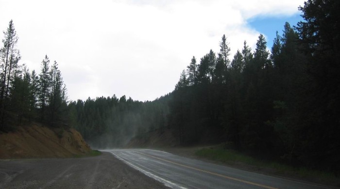
.Fog Is Seen Rising From Sun Warmed Pavement That Had Been Rained -On A Few Minutes Previously.
. [
.go up a long hard grade, .. ] cross the Continental Divide,
. (Cont next)
Pipestone Pass, MT When driving
. up a long hard grade, .. I could see that a railroad also comes through here, but at the top of Pipestone Pass, the tracks are not seen hereabouts. Thus there must be a tunnel way-below this pass. And, indeed, this Railroad and Its Tunnel can be seen in both of the following Maps.
.****************..
...A) RIGHT Click & Select New Tab To See A Topo Map With "Pipestone Pass, MT (6,453 ft) At Center. And indeed also see TUNNEL. AFTER Map Come Up, Immediately Click Upper Left, Symbol For FULL SCREEN. Then A) Wait about 30 seconds for the load of the Topo Map to fill your whole screen. B) A lot of annoying advertisements will be gone. C) DO NOT Click on the BIG GREEN START if this shows.
.You can see the Continental Divide is marked, which can ALSO be seen in Satellite View as a Road & Trail, B) next down.
.****************..
B) RIGHT Click & Select New Tab To See A Satellite View of The Mountains Around Pipestone Pass. AFTER this Satellite View Comes Up, Please Notice: =>
..1) Red Pinpoint marks Pipestone Pass.
..2) Route 2 markers, which here mark the ZMM Route.
..3) From Pipestone Pass, going Northwest => Notice all of the Twisty Curvy parts of Route 2, which nicely fit the ZMM Narrators definition of a Good Road (Quality) Experience!
......4) Below Route 2 markers, see a weaker line. This is the Railroad which
..a) Because it is in a tunnel => The Railroad cant be seen, for a small distance
..before & after Pipestone Pass.
..b) At upper left in Satellite View => The Railroad turns and goes
.straight North to Butte, MT.
..5) On both sides of Pipestone Pass (Red Pinpoint), you see a trail (also a road?), which must follow fairly closely the Continental Divide, which can be seen in TopoZone View, A) next above.
..6) On Trail of 5) Above => Get Out Of Your Car, And Go For A Walk!! This Trail, either South Or North, is a good place to really explore and enjoy the scenery, as is done by the ZMM Narrator!!
..7) This Wikipedia Page Extensively Discusses the RR at Pipestone Pass +Photos,
..8) According To this Wikipedia Article
On This (North going), Continental Divide Trail there is
A trail running race currently takes place annually on the Continental Divide Trail between Pipestone Pass and Homestake Pass. Hosted by Butte's Piss and Moan Running Club, the Wulfman CDT 14 kilometers [8,7 miles] is held on the Saturday closest to the Summer solstice.
9) Homestake Pass (mentioned above) is some 8.7 miles Northeast, and an excellent Tourist Attraction, which Googling Will Reveal, as follows.
10) \ Excerpt From Article About The Singing Rocks At Homestake Pass, MT Says =>
.Heading east on I-90 weaves one up the Continental Divide of the Rocky Mountains and peaks at 6,329 feet at the top of Homestake Pass. On both sides of the road are eye-catching boulder fields, a strange landscape that looks as if a giant dumped his rock collection into piles. This is the Boulder Batholith that formed millions of years ago as magma was rapidly forced upward. At extreme temperatures, it partially melted and thrust aside the surrounding native rock. Pleistocene periglacial freezing and frost-heaving eroded away the soil and exposed the massive boulders.
.[Drive up here] to see a wonderfully weird phenomenon: the Pipestone Ringing Rocks. Upon approaching the Ringing Rocks, it appears that the giant left behind another pile of unwanted stones. However, these are special rocks. So special that there are only four other areas like it in the world: Mexico, England, Western Australia, and Pennsylvania. These rocks ring like a bell when lightly tapped with another hard object. They will chime with different tones and pitches. Bring friends and you can literally jam out with your own rock band.
[End Excerpt.]
.*********************..
. Route 2, Continuing From Pipestone Pass, West Towards Butte, MT, Is Very Twisty Hilly, And Thus Fits The ZMM Narrators Definition Of A Good Road! You Should Be Pleased Use It!!
*************************
(Photo = 109-0958c ...... ZMM Page = 236 ...... WayPt = 238w 6455ft)