Same Camera Location As Previous Photo =>
A View Back Towards Three Forks.
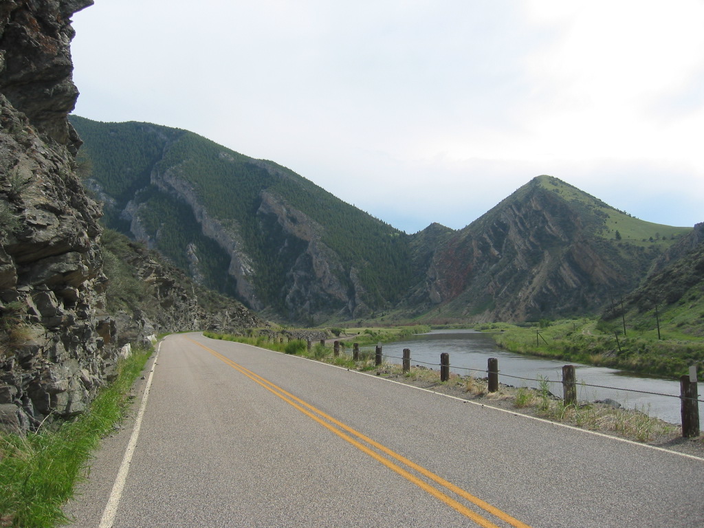
..The Canyon Is So Narrow, the Road Is Jam Tight Against The High Cliff.
.
The River Water Surface Looks Disturbed. But This Appearance Looks More Like Effect Of Wind On Calm Water, Rather Than Showing The Effect Of True Rapids.
[.
. canyon of whitish-tan rock,
. ]
Along The Jefferson River, In The ZMM Narrators => [High Walled] . A Narrow Canyon Of Whitish-Tan Rock ~2 Miles SE Of, Jefferson Island, MT. NOTE: Location is not the ZMM Narrators..At Three Forks . , but some 24 straight line miles West & a bit south.,
.... As was discussed in the SECOND Previous Photo => My 8 Photos of the Jefferson River, mostly show grassy slopes, or rather black looking rocks.
By contrast in the /\ Above /\ Photo, in the slope of the mountains at right, is where you see the tan rock layers of the Narrators => whitish-tan rock .
Right Click & Open In New Tab To View Series Of 3 Photos of Swallows (Birds), That Have Their Nests High Up On The Cliff Face Of /\ Above /\ Photo. These 3 Photos, Are Taken From Base Of The Above-Mentioned Cliff, At Pavement Edge WayPt = 235w
.PHOTO VIEWING NOTE FOR THREE PHOTOS OF SWALLOWS. :
..A) The above-mentioned Photo of Swallows should come up with Full=1, meaning already largest size. And if you click on Next >>, the photo that comes up will also be full size.
..B) In General, To Best See H. Gurr Gallery Photos, Click Photo Several Times To Largest View. Then ClickDrag Sliders To See Parts Off Screen.
..C) In These Three Photos, You Will See =>
.1) View Of Cliff Looking Straight Up: The Swallows Were Frantically Flying All Around Over Me, Because I was Disturbing Their Nesting Sites, Pasted To The Rock Face.
.2) Several Swallow Nesting Sites Are Seen Pasted To The Rock Face.
.3) Close Up Of The Swallows That Were Frantically Flying All Around Over Me.
***********
HISTORY: THREE FORKS OF THE MISSOURI.
..Published On https://www.facebook.com/zmmquality/ by David Matos, 28 July, 2022.
.On July 28, 1805, Meriwether Lewis put pen to paper and recorded a consequential decision
.Both Capt. C. and myself corrisponded in opinion with rispect to the impropriety of calling either of these streams the Missouri and accordingly agreed to name them after the President of the United States and the Secretairies of the Treasury and state having previously named one river in honour of the Secretaries of War (Dearborn's River) and Navy (Smith's River). In pursuance of this resolution we called the S. W. fork, that which we meant to ascend, Jefferson's River in honor of that illustrious personage Thomas Jefferson. the Middle fork we called Madison's River in honor of James Madison, and the S. E. Fork we called Gallitin's River in honor of Albert Gallatin.
.Lewis & Clark and their Corps of Discovery has arrived at the headwaters of the Missouri River on July 25, 1805, Their Lemhi Shoshone guide Sacajawea recognized the area as the place she had been abducted from her people years earlier. A scouting party led by Clark went ahead to the Three Forks, where three meandering rivers merged into the Missouri Rivers. Instead of identifying the largest of these three rivers as a continuation of the Missouri River, Lewis & Clark decided to name it as a tributary, the Jefferson River. As a consequence, the Mississippi River is technically longer than the Missouri River today.
.Lewis, upon arriving at the Three Forks of the Missouri, decided
.beleiving this to be an essential point in the geography of this western part of the Continent I determined to remain at all events untill I obtained the necessary data for fixing its latitude Longitude.
.Sacajawea would eventually reunite with her Lemhi Shoshone in a tearful, affecting reunion, meeting her brother now a chief, and another female abductee who had previously escaped and returned west. Sacajawea and the Shoshones help were crucial in making the Corp of Discoverys expedition a success.
.The Three Forks area is also a site of the legendary escape of John Colter, a member of the Lewis & Clark Corps of Discover who returned to the area to trap beaver in later years. As Colter and a companion canoed up the Jefferson, they found themselves surrounded by hundreds of Blackfeet warriors who commanded them to come ashore. Colters companion resisted and was dispatched; Colter was stripped naked and ordered to run for his life with the Blackfeet in hot pursuit after giving him a headstart.
.Today the Three Forks of the Missouri are part of Missouri Headwaters State Park in Montana. The Gallatin River of course would give the name to Gallatin County that the Three Forks of the Missouri is located in. Sacajawea is honored with a statue on Main Street in the small town of Three Forks, MT. Pirsig fans may appreciate that Lewis & Clark named a tributary of the Jefferson River, now known as Willow Creek, "Philosophy River.
LEARN MORE
http://www.lewis-clark.org/article/2622
ZMMQuality's Henry Gurr's photos and discussion of the Three Forks area...
http://venturearete.org/ResearchProjects/ProfessorGurr/gallery/album08/109_0921c?full=1
First Of 4 Very Nice Aerial Photos Of The Three Forks River Merge To Form The Missouri River, Which Shows => 1) A bit above & left of center is the wide Missouri, forced into narrow channel by Hi Cliffs both sides. 2) At left The Jefferson River. 3) At right The Gallatin River. 4) The straight line is road from town of Three Forks, MT. 5) In center of photo is a flat uniform tan area, which as part of the Headwaters State Park, is a raised rock good for tourist observation.
.Please remember 1) thru 5) which will help you understand the following 3 photos. Start Here =>
https://www.facebook.com/zmmquality/photos/2246099512206388
*****************
(Photo = 109-0935 ...... ZMM Page = 235...... WayPt = 235w 4355ft)