Photo Opens With A View North, Looking Landscape Beyond Montana Highway Rt-2, Which Follows At The Jefferson River Valley from Three Forks, MT. Remember The Yellow Flowers By The Pavement, Then Click Photo Several Times To Get Largest View, And
The /\ Above /\ Photo Shows Scenery Along The ZMM Route, In A Wide, Somewhat Flat Valley, Just Prior To Entering A Very Steep Walled, Narrow Canyon, Possibly Having Whitewater Rapids.
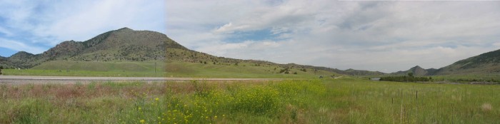
.Starting With A View North: ClickDrag Bar and Gradually Scroll This Panorama To The Far Right, And Now You are Looking East, Back Towards Three Forks, MT.
NOW => Look Closely And You Can See The Wee Tiny Highway Way, Way, Tiny, Into The Distance, At The Lowest Place In The Horizon, Indicating The Valley Location. AND Slightly To The Right, Somewhat Larger, Is The Jefferson River.
AND BELOW LEFT OF => The Tiny Distant Tiny Highway & Tiny River, You Can Dscern a) A Closer River Portion With Still Water River Surface, & b) Railroad Tracks Curving Along Below The Grove of River Edge Trees.
The Railroad Tracks, Continue To The Right Edge, Where Above Them, Can See Considerably More Calm Surface River Water.
.Please Know That Much Of Montana Looks Like The Above Photo Showing => Rounded Green Grass Covered Hills & Small Mountains, .
.[,
. According to the Theory of Relativity, Riemann geometry best describes the world we live in. ]
...At Three Forks the road cuts into a narrow canyon of whitish-tan rock, past some Lewis and Clark caves. ....
Along The Jefferson River, Approaching . A Narrow Canyon Of Whitish-Tan Rock ~2 Miles SE Of, Jefferson Island, MT. NOTE: Location is not the ZMM Narrators..At Three Forks . , but some 24 straight line miles West & a bit south., .]]
....
Where Are Whitewater Or Rapids Along The Jefferson River?
.A forthcoming photo shows and discusses a Montana Historical Marker, which gives Important Evidence That => The Lewis and Clark Expedition navigated this part of the Jefferson River ~August 1. 1805 on its way to find a Northwest Passage further West.
.This Marker, only 1.2 miles upstream from the /\ Above /\ Photo Location, also said the Expedition Crew => Exerted great effort, at great peril, to bring their boats up the river rapids, and indicated the rapids were not too much further downstream, from the Marker location.
..****************..
...A) For An Excellent History Discussion of The Lewis and Clark Expedition, With Emphasis On Expedition Navigation of the Jefferson River, Click Here. AFTER This Page Comes up, To Read About Rapids > Do > Top > Edit > Find > rapids Then Repeat for struggling
...B) For An Excellent Discussion, With Many Photos, Click Here To Read => The Jefferson River Canoe Trail This Page Tells What It Is Like To Navigate Boats On The Jefferson River,.
..****************..
...C) On the Jefferson River, the most likely places for rapids are at the Narrators => the road cuts into a narrow canyon of whitish-tan rock, . This is because the river there has a deep, especially-narrow-cut, through extra hard rock of a small mountain ridge, as may be discerned in a Satellite View, Blue Link Next Below.
. RIGHT Click & Select New Tab To See A Google Satellite View, where the location of Red Pinpoint, marks one of the Jefferson Rivers the deeper-narrow-cut-throughs in this mountain ridge. AFTER this Satellite View comes up, use ClickDrag to study the Mountain Ridge further East. Then you may Zoom-In To see the Closest Clear Image, to study the River bottom, and look for most likely places for rapids.
.The /\ Above /\ and NEXT 7 Photos were taken at a location 3300 feet NW of the Above-mentioned Satellite View Red Pinpoint Marker. By happenstancd there is a An Oval Rt-2 Marker, at this photo location, in the Knowing this, will help you know where are significant landscape features, surrounding these 8 photos.
For Examples, Please Notice The Satellite View, Shows =>
1) At Upper Left => Jefferson Island, MT, where Rt-2 junction at Rt-359.
.. .2) Upper Right Of Jefferson Island, MT, By Rt-2 e=> Lahood Pard. .
3) At Right Of Center => Lewis & Clark Caverns.
4) Further Right Of Center => Lewis & Clark Caverns State Park, Area Of Land.
5) Lower Right => The Campground For => Lewis & Clark Caverns State Park.
6) Notice That The Mountains change to Irrigated Level Valleys along R-359.
.7_ Notice that Rt-2 continues North to I-90, where the ZMM Route turns West to travel to Missoula, MT.
..****************..
NOTE1: a) The Jefferson River flow is greatest during a 4-6 week snow melt-off, about mid-May to mid-June. b) One Fishing WebPage says of this river => The current is usually slow, and irrigation can literally takes a heavy toll on water levels [especially] during drought periods. c) My (Henry Gurr) Photos are about June 24, and thus are well after the higher river flows. d) The Lewis and Clark Expedition, the first several days of August 1805, would have seen the river at its lower flow. But the river flow they experienced, could have been considerably greater than the present day, because of no irrigation back then.
NOTE2: WayPt = 235w is the location of the 5th & 6th Photos Next. These two photos show the deepest, near vertical walls of the canyon.
NOTE3:For he Satellite View (of the Above Blue Link) => What is at ground level for the location of Red Pinpoint, marking the Jefferson Rivers the deepest-narrow-cut-throughs in this mountain ridge => Is FURTHER EXPLAINED in GREAT DETAIL in the FIFTH Photo NEXT. ..****************..
Where Can We Observe Whitewater Or Rapids, Along The Jefferson River?
.My ZMM Field Research along the Jefferson River, was done before I knew river rapids were important: Thus my 8 photos, including the /\ Above/\ Photo, were taken without any attempt to show rapids. What river water my photos do show, by happenstance, shows calm water, except for my 2 photos taken within the Very Steep Walled, Narrow Canyon, which are the 5th & 6th next Photos.
.But here, what appears as possibly rapids, may be simply due to the sharp curve of the river making disturbed surface, rather than show a river water speed where are found true rapids. In fact, in photo 6th Next, the water surface shows NO rapids, but only looks slightly disturbed by light wind.
.
. In a Satellite View, One of The Better Places Where Is Seen The Slight Streaky Whiteness of Whitewater, and Thus Evidence Of Lewis & Clarks Difficult Rapids => Seen Above Word Google At Bottom Center. Click Here. This particular place in the river is especially narrow water, AND a more than ever, sharp turn!
.CAUTION: In this Satellite View, Sand or Sandbars are White Or Whitish. The Whiteness that shows rapids happens to appear as Greenish Whiteness. You will have to study this closely and carefully to See And Understand What You See!!
Elevation Data For The River Might Be Used To Find Rapids, Because Rapids Are Where There Are The Largest Drops In The River Level.
.To Study Elevation, use the WebSite Called ElevationFinder, or use Topographic (Topo) Maps.
.I have spent some time studying the Elevation Contour Lines of the Blue Link below, only to find it is very difficult to see, where Contour Lines cross the Jefferson River, even where I think the river is the steepest. This TopoZone Map Will Come Up Showing (At Center) The Same Location As Above Google Satellite View. The only contour line river crossing I can see is > Lower Left of where it says Lewis and Clark Caverns State Park., at the river, where there is an A in the word MADISON CO. This is not enough info to find rapids.
.Alternately, use Google Maps, Upper Left > Click Three Horizontal Bars > Click Terrain. As you will see, this also shows Contour Lines. But contour line river crossings are even harder to see..
**************
(Photo = 109-0925 +108-0926 + 109-0927sc ...... ZMM Page = 235-236 ...... 232x 4308ft)