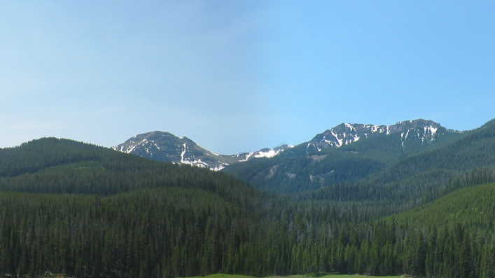
The ZMM Narrator Can Now See Mountain Peaks With Snow. =>
.This Is Seen Beyond a Forested Ridge, That He and Chris Will Eventually Cross Over.
. Just up above the top of the ridge the snow can be seen now. On foot its many days away though. The rocks below it are too steep for a direct hiking climb, particularly with the heavy loads we are carrying, and Chris is way too young for any kind of ropes-and- pitons stuff. We must cross over the forested ridge we are now approaching, enter another canyon, follow it to its end and then come back at an upward angle along to the ridge. Three days hard to the snow. Four days easy. If we dont show up in nine, DeWeese will start looking for us.
Upper Cottonwood Canyon, Gallatin National Forest, MT.
.Here are the clues, so far, as to where the Narrator and Chris have hiked =>
...a) Not far from DeWeese Home: they are in a deep narrow canyon which has very steep sides such that you must look up to see the sky.
..b) They cannot see out the canyon sides, but looking ahead (up canyon) they can see snow, which we learn is 3 to 4 hiking days away.
.NOTE: Although not stated, we may infer that the edge of the snow is their intended goal. My study of Topo Maps, for Gallatin National Forest, shows Mt. Blackmore as one of the better candidates for Summer Snow. This is some 12 miles away, from the DeWeese home depending on route. This calculates as 3 to 4 miles per day
.Considering a typical walking speed is said to be 3-4 miles/hour (and a Trail Hike WebPage says 1.5 miles/hour), we might expect these 12 miles to take 3-4 hours (or 8 hours), and thus wonder why the Narrator allows . Three days hard to the snow. Four days easy.
. Although 3 or 4 days for 12 miles, may seem way too much time, perhaps it is a reasonable speed for mountains with steep slopes, especially considering that the Narrator and Chris are carrying heavy packs. Both are out of shape, and must stop often for long rests.
.Additional Important Clues:
..c) After two days hiking, they will be relatively near a frequently traveled road.
..d) When they turn into a smaller, less traveled canyon, this turns their route away from their snow goal, requiring a later turning back, and continue upward onto a ridge.
..e) All very important clues, especially the ridge which is well above the smaller canyon at this point.
. NOTE: Topo Maps, do show in Cottonwood Canyon, ~2 miles from the DeWeeses => A line of view, directly up-canyon, from where a viewer could see a ridge, in the fore ground, and beyond the ridge would be seen some very high mountains, which would have snow. That this is possible, is confirmed by viewing this in GoogleEarth.
*************************
(Photo = 108-0904+0905sc ...... ZMM Page = 173 ...... Photo Simulate WayPt N+C 05 6140ft = 2.23 mi fm DeWeese.)