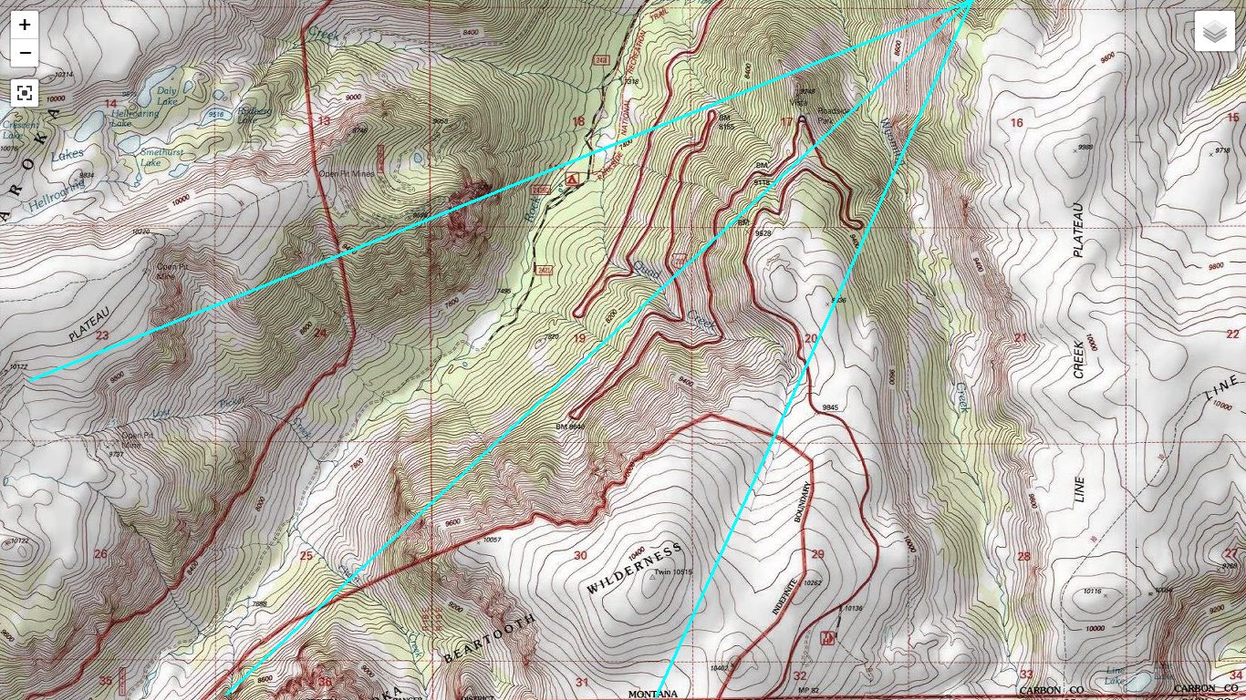
A Topographic Map Showing =>
.The Probable Camera Location Of Mr. Brent Egenes 1945
..Photo Of Road Cuts of Historic Beartooth Highway.
.. =>
....
.
....[
. And up and up, over one of the highest paved roads in the world. I feel some anxiety about this, which I realize is irrational and try to get rid of by talking about the road to the others. Theres no way to fall off. No danger to the motorcycle. ]
Six Switchbacks, Rock Creek Canyon Precipice Edge, Beartooth Highway ~14 Miles South of Red Lodge, MT.
....
....The /\ Above /\ Photo Shows a TopoZone.com Map Of Likely Camera Location, Where Mr. Brent Egenes Took His 1945 Photo Of Road Cuts of Historic Beartooth Highway.
VIEWING INSTRUCTION:
..A) Click On /\ Above/\ Photo until you get largest view.
EXPLANATIONS
..B) To the /\ Above/\ Topographic Map have been added Green Lines showing approximately Mr. Egenes Camera Location, which is at upper right. You see, Mr Egenes chose a location on the Rock Creek edge, of a relatively flat plateau region. The Three Green Lines, show the Center and Two Sides of the View Field. You might go back and re-study Mr. Egenes Photograph, to understand how the Three Green Lines, project to the edges of Mr. Egenes Photograph. (( To go back to previous => Click Upper Left on Left Arrow. ))
..C) In /\ Above/\ Photo, at Lower Left, you see an area labeled Beartooth Wilderness. This is surrounded by a Red Border Line that merely is a Boundary, and is NOT showing a Road.
****
FULL INSTRUCTIONS => To See & Study Further => Using An ONLINE Version of TopoZone Map, Of SAME Landscape Area As /\ Above/\ Topographic Map View Photo =>
. => RIGHT CLICK AND SELECT NEW TAB =>
AFTER Map View Comes Up, You Will See an AWFUL Clutter of Adverts That Are Impossible To Eliminate =>
YOU BEST SHOULD =>
....Use Scroll Bar At Far Right => Adjust Green Topo Map Until Upper Left Until => You SEE-JUST-BELOW The [[Plus & Minus]] => [[Box]] => Do-Mouse-Hover-Over It =>.Shows Full Screen => THEN Click On It, and Adverts Will Be GONE. =>
....
.Then use [[Plus & Minus]] To Zoom. You can ClickDrag Map In Any Direction to See More Off Your Screen Edges.
****
B).The Topozone Map That Comes Up Should Show A Version of the /\ Above/\ Photo, where you see US-212, Zig-Zag Up The Precipice-Side of Rock Creek SW of Red Lodge, MT.
...C) If you see different from B) => Click the [[--]] to Zoom-Out OR [[+]] to Zoom-In, AND THEN => ClickDrag Map In Any Direction, until you see center of screen, /\ Above-/\ Photo View.
. At which point, To See More Of What You Want, you can Zoom OR ClickDrag Map In Any Direction.
D) As You USE the above-mentioned ONLINE Version of TopoZone Map, you will see its Lines are Sharper and the Colors of the Road Lines are more vivid => Than the /\ Above-/\ Photo View.
****
.Next Photo Shows A Frightful Place To Look Way, Way, Way, Down, To Rock Creek.
.... *************************
(Photo = TopoMapCameraPovBrentEgenes1945PixRoadCutsBeartooth Highway1+CameraPOV.jpg ...... ZMM Page = 109 ...... WayPt = 124i ~4500ft.)
