On Approximately The Fifth Tier, Beartooth Highway, MT.
..AND Standing Beside Quad Creek, A Small Mountain Melt-Water Stream =>
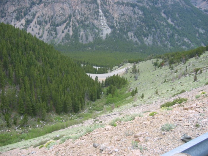
.There Is a Frightful Place To Look Way -- Way Down!
.[ Theres no way to fall off. No danger to the motorcycle. ]
Just a memory of places where you could throw a stone and it would drop thousands of feet before coming to rest and somehow associating that stone with the cycle and rider.
At Switchback curving around In The Melt-Water Cut of Quad Creek, Fifth Tier Up, Beartooth Highway, ~14 Miles After Red Lodge, MT. In the /\ Above /\ Photo => Standing on one tier, you are looking way down along the Cut of Quad Creek, and can discern the valley floor and two other tiers way, way, way down. Although being here is terror-ific, there is a doubled-heavy guard-rail thats nearly continuous, and well maintained. This will not allow that which fear suggests: =>. Going over the edge!
********************
A) INSTRUCTIONS HOW => TO SEE AN ONLINE TOPO MAP OF THE /\ ABOVE /\ PHOTO LOCATION ALONG THE BEARTOOTH HIGHWAY.
..A) SHORT INSTRUCTIONS => For Using The ONLINE Version of TopoZone Maps.=>
..1) On The BLUE WayPt = Number Below => RIGHT CLICK AND SELECT NEW TAB =>
..2) AFTER TopoZone Map Comes Up => Use Scroll Bar At Far Right => Adjust Green Topo Map Until Upper Left => Until you SEE-JUST-BELOW The [[Plus & Minus]] => [[Box]] => Click Go To Full Screen =>
..3) Use [[Plus & Minus]] To Zoom. You can ClickDrag Map In Any Direction to See More Off Your Screen Edges.
****
Suggestions To User: =>
..4) Although TopoZone Maps are a really great resource, they unfortunately do not mark the WayPt = on your screen.
..5) When the TopoZone Map comes up, please know that => The WayPt = is in the EXACT CENTER of your computer Screen.
..6) SUGGESTION => As best you can estimate, place a SMALL ~Sticky Tag Pointer to mark screen center.=> Then Click-On => [[Plus & Minus]] => And IF your Pointer is CORRECT, it will still mark the same relative place on the Topo Map.
..6) Since this ~Sticky Tag Pointer will likely be useful (when you look at a future TopoZone Map), may I suggest you leave it there temporarily.
****
TopoZone Maps have been successfully used on my Windows & Linux Computers (on both Firefox & Chrome).
.Please send email re how well this works for you, on other computers/software.
*************
B) FULL INSTRUCTIONS FOR USING => THE ON-LINE Version of TopoZone Maps =>
.These Instructions, As You Will Remember, Are On The Previous Photo. Right Click and Select New Tab. => AFTER this Page Comes Up, Scroll Down To And Read => FULL INSTRUCTIONS.
..***********************..
NEW TOPIC: A Good GPS Computer APP => When working with GPS Data From Your Camera, Smart Phone, or Handheld GPS Device such as Garmin => You might want use these Two Very Nice TopoGrafix Software Applications installed in your computer. =>
..A) Click Here For Free Computer APP EasyGPS=> AFTER This Page Comes Up, Scroll down to and click on => Download EasyGPS NOTE: Installed in your computer => .EasyGPS is very useful for Downloading (and Uploading) GPS Data to (and from), your Devices. It will also show your Waypoints on a Sort Of A Map, which I which I much use => For Edit Accessing my GPS Coordinates values for my WayPoints. But .EasyGPS will ONLY show towns or roads, on this Map until after you $ Pay To Subscribe.
..B) Click Here For $ Subscribe To Computer APP ExertGPS=> Their Page Says => ExpertGPS is the ultimate GPS map software for planning outdoor adventures. View GPS waypoints and tracklogs from any handheld GPS receiver over aerial photos and US topographic maps. Plan your next outdoor adventure over scanned USGS topo maps and send a route directly to your GPS receiver to guide you in the field. View your GPS tracklog over an aerial photo to see exactly where you went.
ExpertGPS handles all your mapping and data-conversion jobs.
************************* (Photo = 106-0610 ...... ZMM Page = 109 ...... WayPt = .. WayPt = 133w )