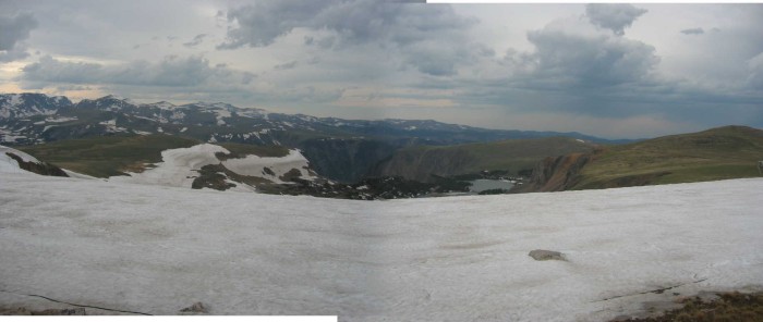
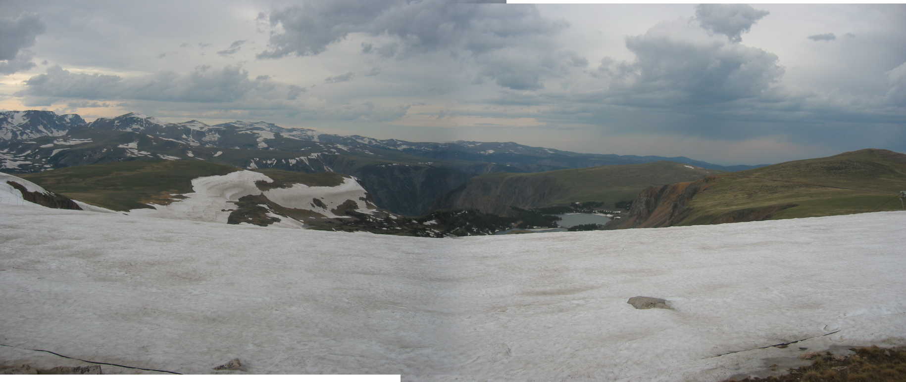
South Of Red Lodge, MT: The First Major Snow Field Is Seen Where Is Also =>
.A Grand Summer Super Steep 10 50 Degree Ski Slope & Ski Lift Area. Being Touristy, This Ski Facility Is UN-MENTIONED By The ZMM Narrator.
.Standing Beside The Ski Lift Parking Lot, and Looking Over the Steep Snow Banks =>
. As Shown & Mentioned In Previous Interlude => a) Satellite View, and b) Topographical Map => We See A Large Side Canyon, As Well As One Of The Twin Lakes.
.From Here, Just Right Of Center We Can Look Beyond A Tree Covered Ridge And See Partway Down Into A Short Section Of Rock Creek Canyon, and Of Course The. Narrators Gorge
. [ I look over my shoulder for one last view of the gorge. Like looking down at the bottom of the ocean. People spend their entire lives at those lower altitudes without any awareness that this high country exists. ]
. The road turns inward, away from the gorge and into snowfields.
.The engine backfires fiercely from lack of oxygen and threatens to stop but never does.
4.9 Miles Straight Line SouthSouthWest of Rock Creek Vista Point Rest Area, and ~2 Miles Direct South Of Montana Border into Wyoming, Beartooth Highway, East Central Beartooth Plateau, WY. Click photo for largest view. A ski lift and parking lot is to the left, in this West view.
..****************..
For A Satellite View of Central Beartooth Plateau, With Summer Ski Area In CENTER SCREEN, Click Here.
..****************..
.The ZMM Narrator Reports His
Engine Backfires Fiercely From Lack Of Oxygen And Threatens To Stop
.My little red car, despite my great fear and worries, had no apparent high-altitude problems at all! This Plymouth, with fuel injection, most certainly had reduced power due to altitude, but at no time was this much evident. I even tested a burst of acceleration briefly several times but saw only a small power reduction. This was just fine, because I was content to drive very slowly, so as to enjoy the scenery and not miss any good photo-ops or ZMM clues.
.My fear was prompted by both the Narrators high altitude problems and my own alarming experience with two other cars at high altitude. Each of those two cars did exactly what the Narrators said above. At lower elevations these two cars (with carburetor engines) were just fine, but as they were driven to higher altitude (over 8000 feet) their backfiring and complete loss of power absolutely prevented further climbing.
.If the Sutherlands cycle had similar problem, it is not mentioned. Was this because its (relatively huge) powerful engine had enough reserve-capacity not to be bothered by reduced oxygen? Or was it because the Narrator (generally) reports only his own problems?
..****************..
The ZMM Narrator Mentions One Last View Of The Gorge. But Nary A Whisper of The Tourist Attraction Ski Area!
.The /\ Above /\ Photo shows The Beartooth Basin Summer Ski Area, which includes a view partway down into a short section of Rock Creek Canyon, O/c The. Narrators Gorge: This factually, is indeed the LAST place to see Rock Creel Canyon {Gorge_ from US-212, because indeed thereafter =>. The road turns inward, away from the gorge
.AND Although the Narrator says I look over my shoulder for one last view of the gorge. [exactly here looking beyond The Twin Lakes], he says nothing about the equally OBVIOUS Beartooth Basin Summer Ski Area with Big Signs immediately beside the Beartooth Highway (US-212).
.As discussed in earlier photos, this is another circumstance where => The ZMM Narrator completely bypassed and never mentions the many, many, quite interesting places, all of them quite close the ZMM travel route!!
..****************..
.For A Google Street View (GSV) Showing Similar To /\ Above /\ Photo, Right Click and Open In A New Tab. AFTER this GSV Comes Up, You May ClickDrag The Left Side Panel To Access More Photos & Panoramas.
*************************
(Photo = 106-0621s ...... ZMM Page = 110 ...... WayPt = 137w & 138w 10,924ft)