Continued From Previous Photo => The Road Then Abruptly Turns Right, To Follow The Curve Around The Melt-Water Cut Of Quad Creek.
. The asphalt of the road is much wider and safer than it occurred in memory. On a cycle you have all sorts of extra room. John and Sylvia take the hairpin turns up ahead and then come back above us, facing us, and have smiles. Soon we take the turn and see their backs again. Then another turn for them and we meet them again, laughing. Its so hard when contemplated in advance, and so easy when you do it.
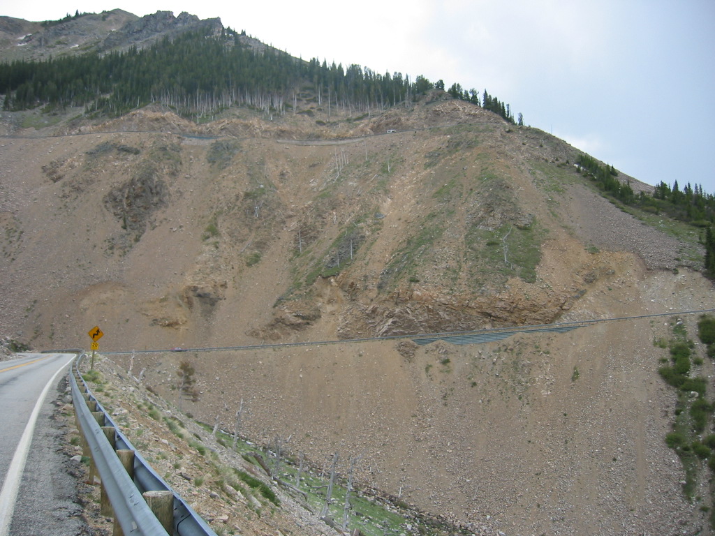
An Abrupt Turn Right, To Follow The Curve Around A Melt-Water Ravine Cut, After Red Lodge, Second Tier Up, Beartooth Highway, MT. In the /\ Above /\ Photo You See => The Highway Entering A Melt-Water Ravine Cut, Quad Creek, Where The Road Abruptly Turns Right To Follow The Curve Around The Melt-Water Cut.
. Then => The continuing road is the gray line angling up (6 % grade), up & off the photo to the right.)
Now look carefully higher up. Thats the highway on the way back after going around the mountain out of view right, completing a switchback (next photo), and then came back around the mountain again!
THUS the /\ Above /\ Photo, shows very likely where the ZMM Narrators above description must have happened: We can then approximately imagine where their motorcycles could have been => One cycle at the camera location for the /\ Above /\ Photo, and the second cycle at the next higher up tier shown.
*****************************
..INSTRUCTIONS HOW => TO SEE A TOPO MAP OF THE /\ ABOVE /\ PHOTO LOCATION, ALONG THE US-212 HIGHWAY.
..A) Short Instructions => Using The ONLINE Version of TopoZone Maps.=>
..1) On The Blue WayPt = Number Below => RIGHT CLICK AND SELECT NEW TAB =>
..2) After Map Comes Up => Use Scroll Bar At Far Right => Adjust Green Topo Map Until Upper Left => You SEE-JUST-BELOW The [[ Plus & Minus]] => [[Box]] => Click Go To Full Screen =>
..3) Use Plus & Minus To Zoom. You can ClickDrag Map In Any Direction to See More Off Your Screen Edges.
****
Suggestions To User: =>
..4) Although TopoZone Maps are a really great resource, they unfortunately do not mark the WayPt =
.
..5) When the TopoZone Map comes up the WayPt = is in the Exact Center of your computer Screen.
..6) Suggestion => As best you can estimate, place a SMALL ~Sticky Tag Pointer to mark screen center.=> Then Click-On => [[ Plus & Minus]] => And IF your Pointer is CORRECT, it will still mark the same relative place on map.
..6) Since this ~Sticky Tag Pointer will likely be useful when look at a future TopoZone Map, I suggest you leave it there temporarily.
****
TopoZone Maps have successfully been used on my Windows & Linux Computers (both Firefox & Chrome).
.Please send email re how well this works for you on other computers/software.
**************************
To Read FULL INSTRUCTIONS => For Using The ONLINE Version of TopoZone Maps. AFTER this Page Comes Up, PLEASE** IGNORE** THE PHOTO & TOP HALF OF READING*** YOU SHOULD IMMEDIATELY => SCROLL DOWN TO AND READ => FULL INSTRUCTIONS. Click Here.
(Photo = 106-0609 ...... ZMM Page = 109 ...... WayPt = 132w )
