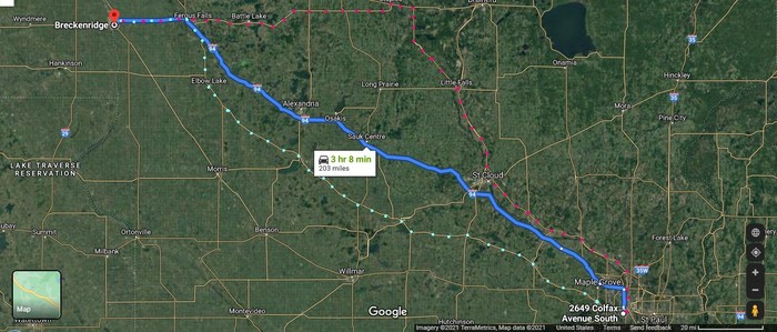
Satellite View Illustrates Speculation As To => What Was The ZMM Narrator's Route Out of Minneapolis That Early Monday, July 1968?
. Chris and I are traveling to Montana with some friends riding up ahead, and maybe headed farther than that. Plans are deliberately indefinite, more to travel than to arrive anywhere. We are just vacationing. Secondary roads are preferred. Paved county roads are the best, state highways are next. Freeways are the worst. We want to make good time, but for us now this is measured with emphasis on "good" rather than "time" and when you make that shift in emphasis the whole approach changes.
Letter from Robert Pirsig 30 Sept 2005 states: Click Here.
. "When John and Sylvia and Chris and I set out that morning we could not have dreamed that 37 years later we would get questions from around the world about which route we were going to take, yet here they are. I wonder what the questions will be like 37 years from now.
. "I've marked up the map you sent me with my best guess, but it could be wrong. The exact route out of Minneapolis is very vague in memory but I seem to recall that we went north to the US 10 highway that still follows the old Northern Pacific railroad (now Burlington Northern) through Anoka, St, Cloud, and Fargo to the West Coast. The freeway that replaced it was I-94. US 10 goes more north than we wanted to go, so after a while we worked our way west and north along a number of roads to highway 210 and followed it to Oakes, North Dakota.
. "The references to Excelsior and Savage [In Mr Pirsigs Book] Lila were for other [shorter] trips that John and I took. Only the first chapter touched down there, not the trip itself. I threw in those names because they seemed to have a mild "not-quite-in-this-world" connotation that might help foreshadow things later on in the book. The name, "Phaedrus," was used for the same purpose.
. "If we had been smarter we probably would have taken Hwy 55 but we didn't really have any route in mind and I don't remember even looking at a map as we left Minneapolis. We just eyeballed it, and went north and west along whatever looked good at the moment. The angle of the sun was our main guide. To really reproduce the feelings of that trip you should just estimate the general direction you want to go and pick a road--any road--and see where it takes you. Road numbers and maps are very static. Not knowing where you're going is more Dynamic and that is how we felt that day."
In The /\ Above /\ Satellite View, You See Three Possibilities For The ZMM Narrator's Route Out of Minneapolis, MN.
..A) According to the ZMM Passage above, I-94 would be measured with emphasis on " time " rather than " good ". , and clearly to be AVOIDED !!.
..B) Marked /\ Above /\ by Red Dots => Mr Pirsig above says very vague in memory is US-10.
..C) Marked /\ Above /\ by Green Dots => But Mr Pirsig goes on to say "If we had been smarter we probably would have taken Hwy 55 .
For The Decisive Reasons Given In The Next Photo, Henry Gurr Continues To Believe That => Green Dots Rt 55 => BEST FITS The Highway Clues In ZMM.
EXPLANATION: Re Mr Pirsigs Above => . "
highway 210 and followed it to Oakes, North Dakota.
.Mr Pirsigs above "a number of roads to highway 210 , refers to Highway Minnesota Rt 210, which the ZMM Route going West, takes up at Fergus Falls, MN, and follows it to the Town of Breckenridge, MN. There the Highway crosses The Rather UN-Noticeable, Red River, and simultaneously leaves Minnesota, enters the Town of Wahpeton ND, and takes up, North Dakota Rt 13.
.This is the road seen in /\ Above /\ Satellite View, at the Upper Left, WHERE you see the Town of Wyndmere, ND. The Road (Rt 13) continuing West, is of Special Significance, since the NEXT Town (Milnor. ND), is where ZMM Route Goes by The ZMM Route Picnic Canopy, a Black & White Photo of which, originally appeared on the => Bodley Head Ltd Publishers of 1974 edition of ZMM.
.AND THEN was placed on the Internet, WHERE => This Photo, Has Become (Ever Since ~1975) => A Famous World Wide Web Photo!
.From This, An Important Major Observation => This ~1975 site comes up very high in Google Searches, despite its non-working links, and the fact that it only has one photo ,and a black & white one at that.
. THUS This ~1975 Webpage Demonstrates The Very High Holding Power Of An Early Start AND from this (in Google searches), still benefits from the many, many sites that still link to here, after all these years!! And despite the fact that there is very little still there, except the Ghost of History!!.
.****************..
As mentioned by Mr Pirsig in his letter above, The ZMM Route (as seen in /\ Above /\ Satellite View), continues along North Dakota Rt 13, to Oakes, ND.
. Forthcoming Photos show views along .this road.
..****************..
All This Exactly Fits The Opening Of ZMM Chapter 3 => Concerning the Red River AND Breckenridge!!
.Here Is what the ZMM Narrator says. =>
By the time we are out of the Red River Valley the storm clouds are everywhere and almost upon us.
.. John and I have discussed the situation [back] in Breckenridge and decided to keep going until we have to stop.
. That shouldnt be long now.
**************************
(Photo = GoogSat 2649S ColfaxAveMinneapolisMN I-94 BreckenridgeMN+Rt55 Gn+US10Rd.jpg ...... ZMM Page = 004 ...... WayPt = NA )