|
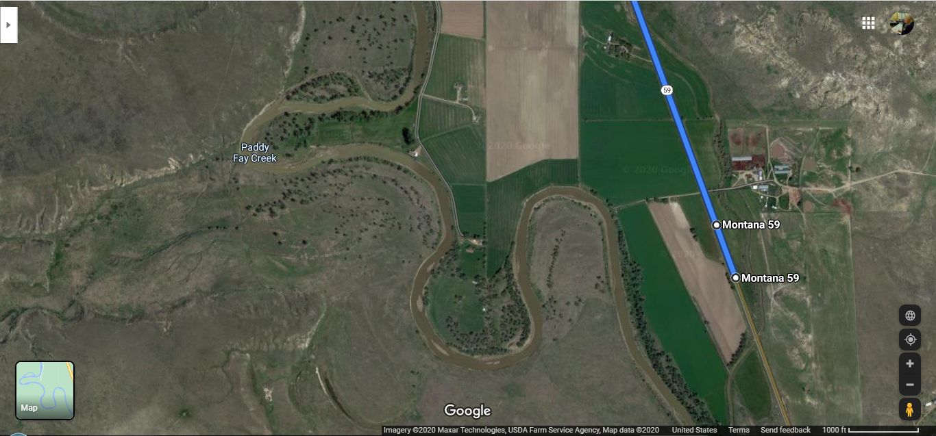
Satellite Image 2020, Irrigated Dry Lands, SE Corner Of Montana, (GPS = 46.318606, -105.764151), Traveling Northwest On Back-Country Rt 59, 8 Miles To Reach Miles City, MT. As youve already surmised
This /\ Above /\ Shows The Long-Lost Panorama Photo-Shoot Location.
DATE-LINE, PART II, SEPT 22, 2020:
. Henry Gurr Has NO Memory Of Where He Did The Photographing Of => The 17 Photos, Shown Previous Panorama Photo & Searched For This Highway Location, Using => GSV Drive the entire route (3 times North-Going & 1 time South-Going.) Do Mouse Right Click & Open In A New Browser Tab, THEN Scroll Down to
=>
How To Use Google Street View:
FINALLY INSPIRATION => USE GOOGLE MAP SATELLITE IMAGES,
..AND Look for the Essential Features Of => A Crescent Shape Of =>
A) Green Fields, Rimmed (to West Side) With A Small Creek,
B) With the Crescent Shape open to the West,
C) Such that Crescent Tips, cross Rt 59 TWICE.
The /\ Above /\ Satellite Photo is the only place that has this Crescent. along Rt 59 from Broadus, MT to Miles City, MT.
Concerning The Physical Location OF /\ Above /\ Satellite Photo ((GPS = 46.318606, -105.764151 )). Where You See Rt 59 TWICE Marked With =>
.. Dot Montana 59 .., You May Confirm This Long-Lost Panorama Location Is INDEED a Hill-Top by studying these two respective, (Sept 2008 Poor Image) GSVs for the /\ Above /\ Rt 59 Marked =>
.A)-Upper Montana 59 for a .GSV View NW see Green&Creek. and
.B) Lower .. Montana 59 for a ..GSV View SE see Green&Creek.
.******************* .
File = GoogSate17PxPano}EssentialCrescentOpenWest}Grn+CreekX2CrossRt59 8milesSwMilesCityMT.jpg
| Upload Date | : | Wed 23 Sep 2020 09:21:40 PM EDT |
|
|||||
|
|
RSS |