ContinuedFmPreviousPhoto.
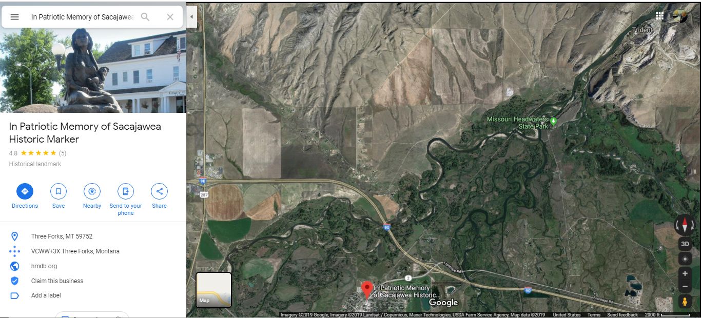
~5:50 pm Mon 6 Aug, A Satellite View, Of THREE RIVERS Forced Into Forming The MISSOURI RIVER At, ZMM Route Town Of, Three Forks, MT.
The Town Is Shown Lower Right In Satellite View /\ Above /\,
..Where you can ALSO SEE weak trace of this road an arrow-straight road going Northeast Toward The Rivers Deep Cut In The Mountain Barrier, Upper Right..
.ALSO IN /\ ABOVE /\ SATELLITE PHOTO
.PLEASE STUDY THE FOLLOWING =>
..(REMEMBER to click photo several ties to get the biggest view.)
AT UPPER RIGHT YOU CAN SEE WHERE =>
.A) There Are Three Rivers, Flowing NE, AND Forced Together Into A Narrow Passage Cut Into Mountains Upper Right.
.This is to the immediate left of where you see weak lettering > Trident, MT. Remember this, because Trident, MT is further discussed Photo Next.
B) AND Despite their meander, You Can Easily Pick Out =.The Three Respective Rivers Of The Three Forks Of The Missouri, That Combine To Form Here The Missouri River Headwaters. =>
1) The; GALLATIN RIVER, which has flow from both Hyalite Creek & Cottonwood Creek, near Tina DeWeeses house. You can partly see that I-90 has been following the Gallatin River Valley, since Manhattan MT.
.2) The MADISON RIVER; which has flow from Western Side of Yellow Stone National Park. This river comes into Three Forks from the SE.
3) The JEFFERSON RIVER, whos watershed comes from nearly all of SW Montana, including Mountains of The Idaho Continental Divide.
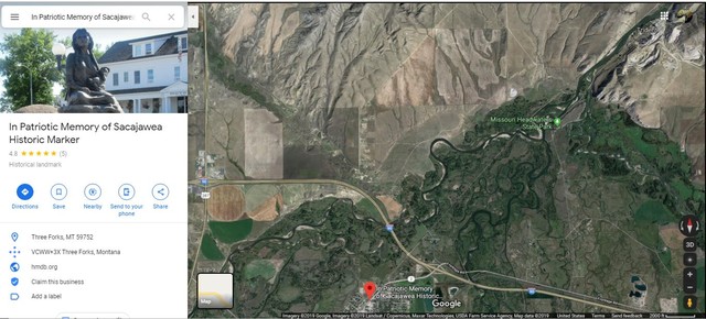
C) In Above Satellite View You Can Also Pick Out The I-90 Interchange For Rt 2, SW Into The Town => Three Forks, MT: << This Interchange is seen lower center, where is the In Patriotic Memory of Sacajawea Historic Marker Erected by the Montana DAR in 1914.
You can explore around in another view of this action in this Google Map =>. . Showing The Swampy Jumbled Area Where Three Forks Of The Missouri, Are Forced By Cut In The Barrier Mountain Ridge, To Form The Missouri River! Here Right Click, And Open In A New Browser Tab..
D) ALSO At Upper Center Of /\ Above /\ Photo => You Can See The Green Map Pin Marker => Missouri River Headwaters State Park. This As You Can See In /\ Above /\ Photo => Marks A Treeless Tan Colored Fort Rock, The NORTHEAST END Of Which Is Shown In (& Subject Of) NEXT PHOTO, AND Much More .
*****************
GOOGLE FINDS INTERESTING INTERNET PAGES OR PHOTOS
Remember to => Right Click, And Open In A New Browser Tab..
..A) Discovering Lewis & Clark: Missouri River Headwaters Expedition Observations & History. . Shows Excellent Photo From View Point Fort Rock, Discussed In This Albums NEXT Photo.
..B) Missouri River Headwaters State Park. Good Description, & Video Good For Area History, Esp
Native American Sacajaweas Roll In Lewis & Clark Expedition.
..C) Fort Rock Trail in Missouri Headwaters State Park, MT. : This has a good Map shoring Visitor Facilities.
.. D) Good Description, For Area History, Esp Lewis & Clark Expedition: Has Planning & Logistics For Visitor. Opens With Excellent & Dramatic Photo From Vista Point Fort Rock, Discussed In This Albums NEXT Photo.
..E) Google Street View (GSV), Opens Showing A View Of Missouri River Cut, About 1 Mile North Of Missouri River Headwaters State Park. This GSP Offers The Ability Rotate full Circle 360 Degrees (~ Panorama), AND You Can GSV Drive, Back to the Cement Plant, & Then Back To the Headwaters State Park & Beyond!
..F) At Trident, MT, A Dramatic Aerial Photo of Missouri River Cut In East Side Mountain, Showing Montana Rail Link's 840 Helena Local RR Train At Holcim's Cement Plant, AND Below Photo, Scroll Down To A Very Nice History Lesson. This is One of A Series of Excellent Photos, By A Montana RR Enthusiast. (Click + or For Huge, & Scroll With Mouse To See All Of Image. THEN => Click (Right OR Left) Arrows To Additional Dramatic Missouri River Mountain-Cut Photos).
Photo File =.
GgMapSati}I90JuncUS287+PatriMemSacajaweaHistMkr+HeadwatersSP.jpg
. Originally Posted May 2019, Revised 9 October 2020.
| Upload Date |
: |
Fri 12 Jun 2020 09:33:32 AM EDT |