Continued From Previous Photo.
4:19 pm Wednesday, 31 July, I-94 Westbound Rest Area ~26 Mi West of Miles City, MT.
As Robert Pirsig says in ZMM => "Now we follow the Yellowstone Valley right across Montana."
Henry Gurrs Book Signing Tour & Big Trip Out-West Brought Him Into Montana from South Dakota, late previous day, 30 July 2019.
.After finishing his 11:00 am to 1:00 pm, Book Signing Event in the Miles City Public Library, Henry Re-Visited ZMM Route Scenes in Miles City, rested under shade trees. then drove West on I-94. About 26 miles West of Miles City, Henry seeing the I-94 Westbound Rest Area, remembers he needed better photos of the Yellowstone River, better than those he took here on his trip here, back in 2002, Click Here.
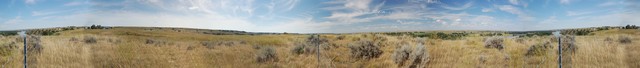
.A 10 Minute Hot Sun Struggle Thru High Brambles & Stickle-Burrs, Yielded The Panorama /\ ABove /\.
. Click Photo several time to gt the largest view , and with magnifying glass, look closely at the right side of the river (just above post), to see a riverside shelf, with RR Tracks! A fact Henry didnt realize until he heard the rumble of a train beneath his feet, while taking this pano-photo, of the River and The Rest Area Buildings.
.Trees Mark The Yellowstone River.:
.With continued Panorama Scrolling to the right (using the Bottom Click&Drag Slidebar), you see the Rest Area Border Fence, and Water & River Banks of the Yellowstone River, and then The Buildings of the I-94 Rest Area. Notice that there are nearly Solid Walls xurrounding the Two Picnic Tables. These walls are Wind Breaks, to partly shelter the Montana Winter Traveler!
Continued scrolling, shows the Fence again, this time toward the West. Continued scrolling, shows the The Same River Scene again.
In /\ Above /\ View And Later Photos Of The Yellowstone River Valley , we see that the valley itself is in relatively flat terrain, so the river itself has almost no downward slope. Thus it is that the Yellowstone River is a wide and calm body of water. This is indeed great for river boat transport such as Lewis & Clark, pioneers, trappers, cattlemen, and the early US Military. And this is reason for Miles City being originally established in a river bay, at the north-flowing Tongue River flowed into the east-flowing Yellowstone River. The first fort was known as the Tongue River Cantonment or the Tongue River Barracks and was founded on August 27, 1876. A second, permanent fort was constructed on higher ground two miles to the west of the mouth of the established in a river bay, the Tongue River north-flowing into the east-flowing Yellowstone River. The first fort was known as the Tongue River Cantonment or the Tongue River Barracks and was founded on August 27, 1876. A second, permanent fort was constructed on higher ground two miles to the west of the mouth of the Toung River [[where it flows into the Yelolowstone River.]
. ((NOTE: If you look at a map, the Tongue River is a major river system, roughly parallel to & (by ~50 miles) West of the Powder River, mentioned and discussed in previous photos. ))
. Indeed, River Valleys in general and especially the Yellowstone River, are often the preferred routes for construction of main roads, including railroads such as we see here!
PANORAMA CREDIT => The More Than Full Circle Panorama, Which You See /\ ABOVE /\ Is From The Skilled Craftsmanship Of FlatWorld.com:
Please NOTICE & REMEMBER The High Quality Of The /\ Above /\ Panorama Photo, Because The NEXT PHOTO Shows SAME CAMERA PHOTOS (And SAME Physical Location), As Panorama /\ Above /\, BUT Stitched. By Less Perfect Efforts of Henry Gurr..
Photo File = 9.jpg = = .Stitch By FlatWorld.com = DSC_0136-0142 RestArea26miW Miles City
. Posted 1 October 2020.
| Upload Date |
: |
Fri 25 Sep 2020 07:39:58 PM EDT |