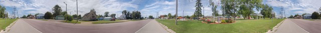
Continued fm Previous Photo => A PANORAMA VIEW Of => Kensington, MN, Centennial Park.
1:24 pm Thurs 15 Aug: ZMM Route (Rt 55), Kensington, MN.
.Kensington is some 145 miles WNW of Minneapolis, MN.
Here Is What The ZMM Narrator Says About The Western Planes Prairie Landscape, As They Approach The Minnesota Border, To North Dakota. =>
[ We are ] not in the Dakotas yet, but the broad fields show we are getting nearer. Some of them are blue with flax blossoms moving in long waves like the surface of the ocean. The sweep of the hills is greater than before and they now dominate everything else, except the sky, which seems wider. Farmhouses in the distance are so small we can hardly see them. The land is beginning to open up.
.There is no one place or sharp line where the Central Plains end and the Great Plains begin. Its a gradual change like this that catches you unawares, as if you were sailing out from a choppy coastal harbor, noticed that the waves had taken on a deep swell, and turned back to see that you were out of sight of land. There are fewer trees here and suddenly I am aware they are no longer native. They have been brought here and planted around houses and between fields in rows to break up the wind. But where they havent been planted there is no underbrush, no second-growth saplingsonly grass, sometimes with wildflowers and weeds, but mostly grass. This is grassland now. We are on the prairie.
. Memories of car trips across them are always of flatness and great emptiness as far as you can see, extreme monotony and boredom as you drive for hour after hour, getting nowhere, wondering how long this is going to last without a turn in the road, without a change in the land going on and on to the horizon.
((NOTE: Of course this fits Henry Gurrs (Non-City) Photos previously seen in this Album, all the way West to the Missouri River. ]]
A City Park Along The ZMM Route, Kensington, MN.
..1) The /\ Above /\ Panorama, Opens With View Southeast along the ZMM Route, Rt 55,
..2) And Using Click&Drag Scroll Bars, to continually scroll the panorama right, you will see a general view of the Town South of Rt 55, until you see again the ZMM Route Rt 55, going Northwest.
..3) Continually scroll the panorama right, you will see a general view of the Kensington Centennial Park (1890-1990), now on the North side of Rt 55, until you see again the ZMM Route View Southeast along the ZMM Route Rt 55, towards Minneapolis, MN.
.For Google Satellite View of Henry Gurr Panorama Camera Location, On ZMM Route 55, Looking Down At Kensington Centennial Park. Click Here.
Please Notice & Remember The High Quality Of The /\ Above /\ Panorama Photo, Because The Next Photo Shows The Same Camera Photos (And Physical Location), As Panorama /\ Above /\, But Stitched By Flatworld.com, Before They Understood & Realized What Henry Gurr Wanted.
Cont Next.Photo =>
Photo File = Panorama_12By98FwRez0706-0711 Centennial Park, KensingtonMN IvSezFa96DPI.jpg
Posted 24 Nov 2020. Revised 28 Oct & 2 Nov & 5 Nov & 24 Nov 2020.