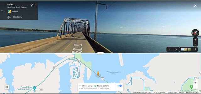
Continued Fm Previous Photo => A Google Street View (GSV) Over The Missouri River.
~7:00 am Wed 14 Aug, Mobridge, SD.
.Henry Gurr In On The Road & Sees Views Like Photo /\ Above /\.
.Please Study & See IN => /\ Above /\ GSV STRIP MAP Left to Right =>
.A) Grand River Casino & Resort (Mentioned In PREVIOUS PANORAMA PHOTO, This Was Shown On High Hill To SW.)
.B) Mid River Island Named Indian Memorial Recreation Area. (The Roads Shown On This Island, Access Added Casino Resort Facilities => Boat Ramp, and Campground, which is Where Henry Gurr Stayed, Last Night.
.C) The Orange GSV Person PegMan Icon, shows Map Location of The Bridge Truss Shown In /\ Above /\ GSV Scene.
D) The Town Of Mobridge, and Location of ZMM Routes A & W Root Beer Restaurant, On US 12, Is Further to SE, and off the Map
Concerning The Bridge", "Mobridge, SD", AND "The US 12 Roadside A & W Root Beer Restaurant Mentioned in ZMM Book" => The ZMM Narrator Says =>
We have lunch of hamburgers and malteds at an A & W place in Mobridge, cruise down a heavily trafficked main street and then there it is, at the bottom of the hill, the Missouri. All that moving water is strange, banked by grass hills that hardly get any water at all. I turn around and glance at Chris but he doesnt seem to be particularly interested in it.
We coast down the hill, clunk onto the bridge and across we go, watching the river through the girders moving by rhythmically, and then we are on the other side.
We climb a long, long hill into another kind of country.
It all has a natural tidiness.
Reservation land."
This GSV Is good, since it => In addition to 360 deg Full Circle Panorama,. it offers you ability to GSV drive and see more Central South Dakota Landscape on down the road! Click Here. You Could See For Example => A stretch of US 12, On The Bridge moving over The Missouri River, and onto the ZMM Narrators Truss Bridge Scene, where traveling this same bridge, he says => girders moving by rhythmically, , then continue Into & through Mobridge, SD.
(ChangesSinceHSGTrip02.)
.The ZMM A & W Place is no longer there.,
Cont Next.Photo => A SATELLITE View US 12 From McIntosh, SD Thru Mobridge, SD, Then US 83, North To Herreid, SD AND Seeing Glacial Potholes.
Photo File = GoogStVuAug2009 MapIsland US12GoingEastZmmRouteTrussBridgeMissouriRiver MobridgeSD.jpg
Posted 19 Oct 2020. Revised 19 Oct & 5 Nov & 21 Nov 2020.