ContFmPreviousPhoto => A LESS THAN PERFECT PANORAMA VIEW => Overlooking Yellowstone River Valley, From Frontage Road of Combined US 12 & I-94.
7:04 pm Mon 12 Aug, Old US 10, Rosebud, MT.
After Miles City, MT And Beginning of Chapter 9,
Robert Pirsig says in ZMM =>
."Now we follow the Yellowstone Valley right across Montana."
And Somewhat Later
Beginning of Chapter 10 =>
. Outside in the valley again the sky is still limited by the bluffs on either side of the river, but they are closer together and closer to us than they were this morning. The valley is narrowing as we move toward the rivers source.
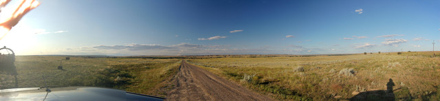
.NOTE: The /\ Above /\ Panorama Photo Shows The SAME CAMERA PHOTOS (And SAME Physical Location), As Previous Hi Quality Panorama Photo, But Stitched. By Less Than Perfect Efforts of Henry Gurr, Using Available APPs.
..AND the /\ Above /\ Photo Is Kept Here, So You may See The Difference.
.Which as you can see, the Photographic Quality is acceptable, but
The Less Than Perfect Stitching Of Henry Gurr shows at center of Panorama, Darkened Sky, unfortunately includes only 4 of the 8 Photos Supplied. This is because APPs Henry Gurr used, would NOT assemble ALL the photos supplied. Ultimately caused by Henry Gurrs inadequate Panorama Photographing Technique. The Previous Panorama Photo Stitched & Edit Improved by FlatWorld.com is Far Better.
.**************
.
..A ~160 deg Panorama View, Overlooking Yellowstone River Valley. From Frontage Road (Traveling East On Frontage Road, Which Runs Along The North Side of Combined US 12 & I-94),
..1) The /\ Above /\ Panorama opens looking Northwest: And scrolling to right, you see a mail box, and then A Line Of Dark Green Trees. And continued scrolling, watch The Dark Green Trees Till You See A Gravel Drive,
..2) REMEMBER to click photo several times to get the biggest view, & possibly use Magnifying Glass, Looking close, and continued scrolling, The Dark Green Trees you see, are at the Yellowstone River. Continued scrolling you see Light Green Of Irrigated Fields And Scattered Buildings, which are along the River. Beyond the river you see a near Continuous Line Of Steep Vertical Cliffs, on the North side of the River.
. EXPLANATION; Here the River has curved, and actually runs towards, and gets close to Old US 10, and the Combined US 12 & I-94, before the River Curves the other way to swing by Rosebud, MT.
.3) And scrolling to right, you see Closer Scattered Trees & A Small White Sign, below which you can magnify to see a stretch of Old US 10. Continue scroll, you See How Burned Dry All Is!!
..4) Scrolling further right you see wire fence & posts which are along The Marginal Road.
.SIDE NOTE: For the River to erode some 500 feet below these Cliffs, says the River has been here a LONG TIME.
Next Photo => Traveling The ZMM Route At 4386 Old US 10, Rosebud. MT.
Photo File = DSC_0534-0538-0541_stitch=MsoftCompositEditor11miEstOfForsythMT
Posted 4 June 2020, Revised 18 May & 16 Oct & 19 Oct, & 11 Nov 2020