ContFmPreviousPhoto => A PANORAMA VIEW AT MINNESOTAS MAPLE LAKE, SHOWING THE ZMM NARRATORS =>
. .. marsh grass and water + A Stretch of The Once-Upon-A-Time Narrators
bump along the beat-up concrete between the cattails and stretches of meadow..
8:42 am Fri 16 Aug: One mile SE of Town of Maple Lake, MN.
.The /\ Above /\ View Is ZMM Route (Rt 55), some 45 miles WNW of Minneapolis, MN. (Although it is possible that Our ZMM Riders stopped here, there is no evidence for this.)
Concerning This Area of Minnesota, Here Is What The ZMM Narrator Says In The Third Paragraph of Chapter 1: =>
... Im happy to be riding back into this country. It is a kind of nowhere, famous for nothing at all and has an appeal because of just that. Tensions disappear along old roads like this. We bump along the beat-up concrete between the cattails and stretches of meadow and then more cattails and marsh grass. Here and there is a stretch of open water and if you look closely you can see wild ducks at the edge of the cattails. And turtles. . . . Theres a red-winged blackbird. I whack Chriss knee and point to it. "What!" he hollers. "Blackbird!" He says something I dont hear. What?" I holler back. He grabs the back of my helmet and hollers up, "Ive seen lots of those, Dad!" "Oh!" I holler back. Then I nod. At age eleven you dont get very impressed with red-winged blackbirds. You have to get older for that. For me this is all mixed with memories that he doesnt have.
. **************
.
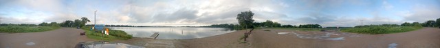
..1) The /\ Above /\ Panorama opens looking West, over an Example of The ZMM Narrators
and then more cattails and marsh grass. Here and there is a stretch of open water And
..2) Remembering to click photo several ties to get the biggest view, & possibly use Magnifying Glass), you can see BEYOND the .. marsh grass and water => A Asphalt Pavement stretch of The Once-Upon-A-Time Narrators
bump along the beat-up concrete between the cattails and stretches of meadow.. which as your see /\ Above /\ is now very smooth Rt 55 Asphalt Paved, atop a Filed-In & Built Up Earthen Embankment, which is identified by the string of Four Sets of Electric Power Poles .
..3) Using Click&Drag Scroll Bars, to scroll the panorama right, you see => A curved stretch of pavement, which at one time followed the curved path of the original old road, on a curved stretch of land between Maple Lake & another major lake to the SW, Click Here, Evidently this was location of the old (dirt?) road prior to making Rt 55 straight (and paved), by Filling-In & Building Up in the lake mentioned in ..2) above.
..4) Continuing to scroll you see successively => a) A Roadside Rest Area, b) Trees, c) The Water of Maple Lake, d) Boat Dock, e) Boat Ramp, f) A Line Of Wood Posts, g) Parking Lot With Puddles from last nights hard rain & wind (Fortunately Henry Gurrs Tent held the onslaught), h) another section of Rt 55, and i) The Rest Area Entrance & Exit.
..5) Look carefully beyond the Stop Sigh, you can see, beyond the Filling-In & Building Up to make Rt 55 straight, the water of the above mentioned another major lake.(All of these lakes & roads are clearly shown Blue Link above.):
..6) And finally scroll to End Of Panorama, to see again the SAME Opening View, showing Narrators
bump along the beat-up concrete
. and then more cattails and marsh grass. Here and there is a stretch of open water .
Photo File = DSC_0015.jpgByFw98RezDSC_0015-0021Rt55Ra&BoatRampMapleLake MapleLake MN DSC_0015.jpg.
Posted 6 Dec 2020. Revised 6 Dec 2020.