|
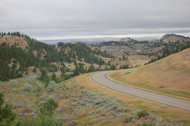
7:53 am Tues 13 Aug 2019: To Get This Better View, Henry Gurr Climbed To Top of South Bluff, of US 12, Slightly West of The Top of the Major Ridge, ~10 Miles East of Miles City MT. ,
.Being in such a view (as shown photo above), The ZMM Narrator Ends Chapter 8, and Ends ZMM Part I. ,
This is all so new. And we are so in need of it, a new rain. My clothes become wet, and goggles are spattered, and chills start and feel delicious. The cloud passes from beneath the sun and the forest of pines and small meadows gleams again, sparkling where the sunlight catches small drops from the rain.
We reach the top of the climb dry again but cool now and stop, overlooking a huge valley and river below.
"I think we have arrived," John says.
Sylvia and Chris have walked into the meadow among the flowers under pines through which I can see the far side of the valley, away and below.
I am a pioneer now, looking onto a promised land.
********************
It is an observed fact that => The increase in elevation of 735 Ft, from Powder River >> To>> US 12 at Main Ridge Road (3127 Ft.), is enough higher in elevation for extra rain, thus creating forested meadows, which the ZMM Narrator Delightfully Reports!!
As seen in the Satellite Views of this Album; =>,
These locations of cooler temperature and extra rainfall are the causes of the darker green areas. .And these darker green areas (usually forested), can be used to discern relative landscape elevation: The Five Satellite Views of This Album have effectively shown these landscape features:
Sincerely Henry Gurr 7 May 2020
DSC 0559
|
|||||
|
|
RSS |