Added July, 2004
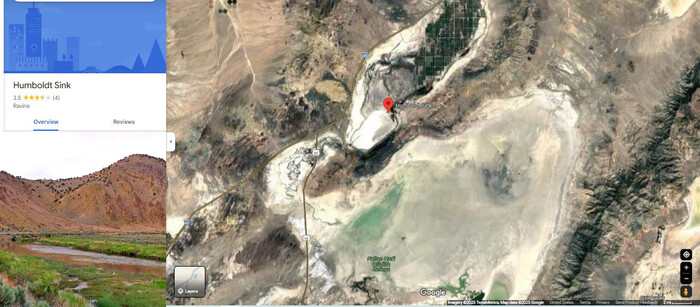
A Google Satellite View Shows David Matos & Henry Gurr Travel Route, Which Was =>
Along I-80, On The Western Edge Of The Humboldt Sink, As Seen In /\Above/\ Satellite View.
To Bring Up The /\Above/\ Satellite View, Click Here. And AFTER Comes Up, Conduct Your OWN ClickDrag Exploration (Plus Zoom In For More Detail)
********************
EXPLANATION: HUMBOLDT SINK =>
The Humboldt Sink, is where, because there is no outlet, the Humboldt River comes to an end, and dries up in Nevadas Fierce Summer Heat,
.. When Henry Gurr came this way in ~1968, and was astonished because suddenly by the highway, in the middle of this awful awesome desert, was this great expanse of green between abundant water channels!!
And Henry remembering all this, wanted to see it again!!
. But, no matter how far we drove along I-80, by the areas shown on map labeled Humboldt Sink, there was NO GREEN!!! In fact, Henry Was shocked to see just dry, dry, dry, flat-pan. with no dried-up vegetation, or dead trees, to indicate there had ever been any water here!!
..In fact we sent so much attention to searching, Henry forgot to take any photos!!
Thus, The Next Scenes Are Shown, And Explained, In Forthcoming 3 Google Street Views.
********************
The NEXT Photo (A Google Street View), Was Taken Where You See In The /\Above/\ Satellite View, The Red & Blue I-80 Icon, And
The SECOND NEXT Photo (A Google Street View), Shows The Humboldt Sink Vegetation & Water Channels, Which Was Taken About 4 Miles East I-80, Where You See In The /\Above/\ Satellite View, The Red Pinpoint.
The THIRD NEXT Photo (A Google Street View), Was Taken Where You See In The /\Above/\ Satellite View, The Roadway Of I-80, That Goes Into The Grid Of Farm Land At Top Of /\Above/\ Satellite Image.
********************
File = ScrnCapt GoogSaVu HumboldtSink ByI-80RedBlueIconTk2GSV AtRedPinTkOneGSV (1)