|
|
Album: In This Photo Album, You Will See Views Of David Matos July 2024 Travel, In San Francisco, CA.
And Then On Their Way Home To Aiken, SC, Visit Stutter's Fort In Sacramento, CA, Non-Stop Thru Las Vegas & Lake Mead. Photo Time At Bolder Dam (Hover Dam), Plus The REALLY Grand Canyon. & Brief Stop At Meteor Crater. |
|
|
|
|
|
Gallery: Photos Illustrate Pirsig's "Zen Art Motorcycle Maintenance"  Album: In This Photo Album, You Will See Views Of David Matos July 2024 Travel, In San Francisco, CA.
And Then On Their Way Home To Aiken, SC => Visit Stutter's Fort In Sacramento, CA, Non-Stop Thru Las Vegas & Lake Mead. Photo Time At Bolder Dam (Hover Dam), Plus The REALLY Grand Canyon. & Brief Stop At Meteor Crater:
Album: Album: In This Photo Album, You Will See Views Of David Matos July 2024 Travel, In San Francisco, CA.
And Then On Their Way Home To Aiken, SC, Visit Stutter's Fort In Sacramento, CA, Non-Stop Thru Las Vegas & Lake Mead. Photo Time At Bolder Dam (Hover Dam), Plus The REALLY Grand Canyon. & Brief Stop At Meteor Crater.
Album: In This Photo Album, You Will See Views Of David Matos July 2024 Travel, In San Francisco, CA.
And Then On Their Way Home To Aiken, SC => Visit Stutter's Fort In Sacramento, CA, Non-Stop Thru Las Vegas & Lake Mead. Photo Time At Bolder Dam (Hover Dam), Plus The REALLY Grand Canyon. & Brief Stop At Meteor Crater:
Album: Album: In This Photo Album, You Will See Views Of David Matos July 2024 Travel, In San Francisco, CA.
And Then On Their Way Home To Aiken, SC, Visit Stutter's Fort In Sacramento, CA, Non-Stop Thru Las Vegas & Lake Mead. Photo Time At Bolder Dam (Hover Dam), Plus The REALLY Grand Canyon. & Brief Stop At Meteor Crater.
|
|
|
|
Added July, 2004
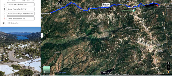
A Google Satellite View Shows David Matos & Henry Gurr Travel Route, Saturday, July 27 2024 =>
Emigrant Gap, CA THRU I-80 & Donner Pass Road CA (Old US-40) OVER Donner Sumit Bridge (Rainbow Bridge) TO Donner Memorial State Park, CA.
NOTE: Left Is List, Supplied By The User, To Easily and Nicely Create This Travel Route On This Google Satellite View.
Interesting Information About The Road Over Donner Pass, And About The Unique & Pioneering Reinforced Concrete => Donner Summit Bridge
Which Is Also Knows As Rainbow Bridge, Because, It Has A Curved Arch. Like A Rainbow. Click Here.
Wikipedia Says =>
Donner Pass is a 7,056-foot-high (2,151 m) mountain pass in the northern Sierra Nevada, above Donner Lake and Donner Memorial State Park about 9 miles (14 km) west of Truckee, California. Like the Sierra Nevada themselves, the pass has a steep approach from the east and a gradual approach from the west.
The pass has been used by the California Trail, First transcontinental railroad, Overland Route, Lincoln Highway and Victory Highway (both later U.S. Route 40 and still later Donner Pass Road), as well as indirectly by Interstate 80. The pass gets its name from the ill-fated Donner Party who overwintered there in 1846.
Today the area is home to a thriving recreational community with several alpine lakes and ski resorts (Donner Ski Ranch, Boreal, and Sugar Bowl). The permanent communities in the area include Kingvale and Soda Springs, as well as the larger community below the pass surrounding Donner Lake.
History
To reach California from the east, pioneers had to get their wagons over the Sierra Nevada mountain range. In 1844 the Stephens-Townsend-Murphy Party followed the Truckee River into the mountains. At the head of what is now called Donner Lake, they found a low notch in the mountains and became the first overland settlers to use the pass. The pass was named after a later group of California-bound settlers. In early November 1846 the Donner Party found the route blocked by snow and was forced to spend the winter on the east side of the mountains. Of the 81 settlers, only 45 survived to reach California; some of them resorting to cannibalism to survive.[5][6]
On January 13, 1952, 222 passengers and crew aboard a train became stranded about 17 miles (27 km) west of Donner Pass at Yuba Pass, on Track #1 adjacent to Tunnel 35 (on Track #2), at about MP 176.5. Southern Pacific Railroad's passenger train City of San Francisco was en route westbound through the gap when a blizzard dumped so much snow the train was unable to move forward or reverse. The passengers and crew were stranded for three days
Central Pacific Railroad
,,,In the spring of 1868, the Sierra Nevada were finally overcome by the Central Pacific Railroad (CPRR), after almost three years of sustained drilling and blasting through granite, with the successful completion at Donner Pass of its 1,659-foot (506 m) Tunnel #6 (a.k.a. the Summit Tunnel) and associated grade, thus permitting the establishment of commercial transportation en masse of passengers and freight over the Sierra for the first time. Following a route first surveyed and proposed by CPRR's original Chief Engineer, Theodore D. Judah (18261863), the construction of the four tunnels, several miles of snowsheds, and a hand-crafted stone retaining wall 75-foot tall (a.k.a. Chinese or China Wall in recognition of the Chinese builders) necessary to breach Donner Summit constituted the most difficult engineering and construction challenge of the original SacramentoOgden CPRR route. *** SNIP ***
For Complete Wikipedia Article, With Two Maps, Two Panoramas & 6 Photos. Click Here.
********************
BECAUSE HENRY GURR ENTIRELY MISSED THE TURN OFF July 27, 2024 =>
NECESSARY INSTRUCTIONS; HOW TO TRAVEL TO SEE DONNER PASS:
From Sacramento CA, Traveling Northeast on I-80, soon after Cisco Grove, CA or Rainbow, CA, look for an exit that says Donner Pass Road. This is old US-40, but signs will NOT tell you this, nor tell you the sights to be seen.
Possibly you may see a sign for Donner Sumit Bridge or Rainbow Bridge, but dont count on it!
You could Zoom-In on the Blue Link below, and see what the road looks like, where leaves I-80, and turns toward Donner Pass.
********************
You May Bring Up The /\Above/\ Satellite View, And Conduct Your OWN ClickDrag Exploration (Plus Zoom In For More Detail). Click Here.
********************
File = ScrnCapt EmigrantGapCA DonnerPassCA RainbowBridge DonnerMemorialStateParkCA (1)
|
|
|
Gallery: Photos Illustrate Pirsig's "Zen Art Motorcycle Maintenance"
Album: In This Photo Album, You Will See Views Of David Matos July 2024 Travel, In San Francisco, CA.
And Then On Their Way Home To Aiken, SC => Visit Stutter's Fort In Sacramento, CA, Non-Stop Thru Las Vegas & Lake Mead. Photo Time At Bolder Dam (Hover Dam), Plus The REALLY Grand Canyon. & Brief Stop At Meteor Crater:
Album: Album: In This Photo Album, You Will See Views Of David Matos July 2024 Travel, In San Francisco, CA.
And Then On Their Way Home To Aiken, SC, Visit Stutter's Fort In Sacramento, CA, Non-Stop Thru Las Vegas & Lake Mead. Photo Time At Bolder Dam (Hover Dam), Plus The REALLY Grand Canyon. & Brief Stop At Meteor Crater.
|
|
|