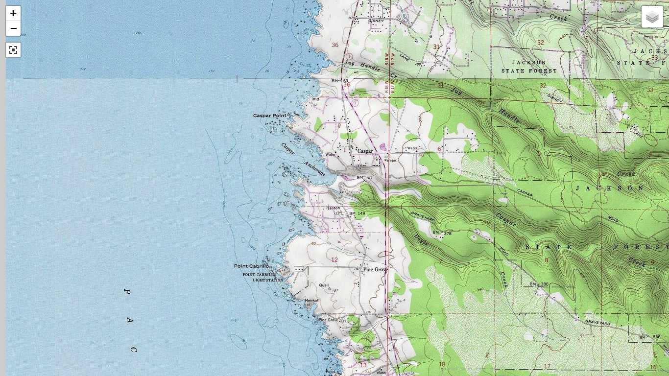
A TopoZone.com, Topographic Map Of Caspar, CA, Caspar Back Bay, Caspar Beach, And Caspar Headlands:
Topographic Maps, Can Often Better Show The Steepness of Slopes, Than Satellite Views.
. To bring up & study the /\Above/\ TopoZone Map of the Caspar, CA Area => Click on the Blue Link below, and AFTER the map comes up, you will see the old Rt-1 Road, as the short dead-end-SE angle-down-segment above the letters BM. From this, you can visualize that the OLD Rt-1 Road crossed the back-bay between the BM and the 41 on the TopoZone Map.
. To See Caspar, CA and Caspar Bay on a Topo Map => RIGHT CLICK AND SELECT NEW TAB.
An AFTER Map View Comes Up, You Will See A Clutter of Adverts, That Are Impossible To Eliminate =>
.SO YOU BEST SHOULD => Use Scroll Bar, At Far Right, To Adjust Green Topo Map Until => JUST BELOW The Plus&Minus Upper Left,.You See => A ClickOn For Full Screen. Click On It, And Adverts Will Be GONE.
.Then Use Plus&Minus To Zoom. You Can Click&Drag Map In Any Direction, To See More Off Your Screen Edges.
********************
The Previous Satellite View Photo, Was A Screen Capture.
For Further Study You May =>
. Right Click And Select New Tab: And AFTER This Satellite View Comes Up, You May ClickDrag To See Parts Off Scree Edges, And Click Lower Right, To Zoom In.
********************
In My 2002 ZMM Route Research, I was UN-able to find this old road down the cliff on the North side of the Bay. This is the reason for no photos of it.
.But the NEXT TWO Photos, will show this Old Rt-1, AND The Trestle Bridge, Very Clearly =>
a) 1947 Aerial View.
b) 1939 National Geographic Color Photo.
********************
(Photo = TopoZone TopoMap CasparCA and Surroundings01.jpg ...... ZMM Page = 366 ...... WayPt = 464w 0040ft)