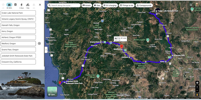
A Satellite View Of Oregon ZMM Route FROM Crater Lake National Park At Top Right Of Center, THRU Klamath Falls, THRU Ashland, THRU Medford, THRU Grants Pass, TO Crescent City, California, At The Pacific Ocean Coast, Lower Left, At Smaller Red PinPoint, .
At Lower Left Corner => Is Wonderful Lighthouse, Which Is Seen At Public Beach, At Ocean Side Of Crescent City, CA.
********************
SO YOU WILL HAVE NEEDED INFORMATION FOR APPROXIMATELY THE NEXT 30 FORTHCOMING PHOTOS,
IN THE ABOVE SATELLITE VIEW, PLEASE NOTICE & REMEMBER THE RELATIVE ZMM ROUTE LOCATIONS OF =>
Crater Lake National Park, (Top Right Of Center), Medford (At Large Red PinPoint), And Grants Pass, Oregon (At Center), And Crescent City, CA (UnLabeled, At Smaller Red PinPoint, Lower Left).
.ALONG THE BOTTOM OF SATELLITE VIEW => Please Especially Study The Marked Route FROM Klamath Falls TO Asland. => As Pointed Out By ZMM Book Expert Lee Glover =>
This Klamath Falls To Ashland Route, Is VERY Likely The 40 Miles Of Oregon Road, Traveled By Author Robert Pirsig In 1968, Where, Along An Oregon Road, About Which, He Stated In ZMM =>
After a few minutes the road reaches a summit and then drops steeply into a valley that becomes more exquisite as we descend. I never thought I would call a valley thatexquisitebut theres something about this whole coastal country so different from any other mountainous region in America that it brings out the word.
This You May See In => An Album Of Photos Showing Views Along The Above-Mentioned 40 Miles Of Oregon Road.
Click Here, And AFTER This EIGHT Sub-Albums Page Comes Up, Read & Remember What Is Here. THEN Click On The SIXTH Sub-Album That Says = THIS IS: A SUPPLEMENTAL ALBUM FOR ZMM BOOK PART IV: Photos Illustrating The Most Likely ZMM Route Of Travel ZMM In Oregon FROM The Small Town Of Klamath Falls, Oregon, TO About 40 miles Northwest of Ashland, Oregon. These Include Views Of The ZMM Narrators Exquisite Valley.
********************
NOTE: Monday, July 22, 2024:
After LaPine, Oregon, As David Matos & Henry Gurr Continued South on US-97, they saw the Narrators =>
.Farther south we find a forest of scrubby trees,
And we saw (and photographed) many Interesting Plants & Flowers along the ZMM Route, to Crater Lake National Park.
. And we saw & photographed many, many great views at Crater Lake National Park.
Further Southwest, we did not find more sights worthy of stopping. Especially so, since Henrys 2002 ZMM Route Research Photos were/are good & sufficient, and can be viewed in photos forthcoming.
AND, we really could not take time for any photo stops, since time was getting short to meet Bill Quaccia & Blue Nelson at The Welders Shop near Grants Pass, Oregon.
********************
You May Bring Up The /\Above/\ Satellite View, And Conduct Your OWN ClickDrag Exploration (Plus Zoom In For More Detail). Click Here.
********************
NOTE1: In The /\Above/\ Satellite View, In The (At Lef)t) List Of Locations, several Added Locations Were Necessary, So Google Maps Would Correctly Show, The Approximate Route Followed By David Matos & Henry Gurr, Monday, July 22, 2024, which in turn is mostly the 1968 ZMM Route:
The above-mentioned Added Locations, at Keno & Cascade National Monument, have no importance, for the ZMM Route.
NOTE2: The Simpson Reed Grove (Lower Left), having many Giant Redwood Trees, at Jedediah Smith State Park, is located on US-199, 6 miles Northeast of Crescent City.
NOTE3:The next photos are => Along the ZMM Route, After Grants Pass, Oregon, The Narrator here leaves unmentioned ~50 miles of travel along US-199, through lower altitude rural scenery, where landscape alternates FROM: wooded forest, TO: Houses & scattered businesses.
Then US-199 Climbs Up To A High Mountain Pass, and after the California-Oregon Border, ZMM Narrator here leaves unmentioned 50 miles of travel, and a tremendous range of Mountain Scenery, And Red-Wooded Landscape changes.
NOTE4: For this above-mentioned NOTE 2, stretch of US-199, David & Henry did not find other sights worthy of stopping. Especially so, since Henrys 2002 Photos were/are sufficient, and can be viewed in forthcoming photos.
NOTE5: Henry Gurrs 2002 ZMM Route Research, By Happenstance Did A Forced Stop, And Found A California Canyon With Two VERY Interesting Phenomena Which The ZMM Enthusiast Should Closely Stuey, When This Canyon Photo Is Encountered!
NOTE 6: The Photos you see next, were taken along the California Coast Highway, US-101. The first Photo, being at the beach just south of Crescent City.
********************
File = ScrnCap GoogSatKlanathFl Ashland Medford GrantsPass.JedediahRedWd CrescentCity (1).jpg