Wednesday, July 24, 2024:
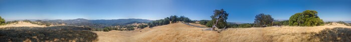
About 17 Minutes After The Previous Panorama Photo, Some 9 Miles Northwest Of Ukiah, CA: A Panorama View Over The Highest Hills, That David Matos & Henry Gurr Encounter Along The Comptche-Ukiah Road, Which Is The Same As. The Orr Springs Road.
The Left End Of This Panorama Shows A View Looking Northeast, Opposite The Sun, And In The Distance, You See TWO Tiny Portions Of The Road Heading To Ukiah, CA. (NOTE: Because This Panorama, Like Many Of Them), Goes One Photo Beyond 360 Degrees, You See Again These => TWO Tiny Portions Of The Road Heading To Ukiah, CA.)
Mid Panorama You See A Portion Of The Road Coming This Way From Montgomery Woods, In The Same Direction As Our Toyota Prius, Where David Matos Parked It, To Be Away From Traffic.
NOTE:
.. Having traveled this portion of the Comptche-Ukiah Road, for ZMM Route Research in 2002, Henry Gurr remembered, that better Panorama Views were needed.
Thus as they neared the highest mountain areas between Orr Hot Springs & Ukiah, CA, Henry looked for the highest place that would have a good 360 degree overview. Thus, the above Panorama is very nicely, the result!
You May Bring Up .A Satellite View Of The Location Of The /\Above/\ Panorama Photo, On The Orr Springs Road, And Conduct Your OWN ClickDrag Exploration (Plus Zoom In For More Detail) . Click Here.
File = DSC 0088 PhotoSetOfHgUploadFeb272025#8 HiPtUhiahRdOK Resize3344x400