Saturday, July 20, 2024:
Driving The NEWER US-95, We Stop In A Big Rest Area Parking Lot, To Take In The Fantastic View.
But At That Time, David Matos And Henry Gurr Did NOT Realize The Significance Of The Following =>
July 2024 Added:
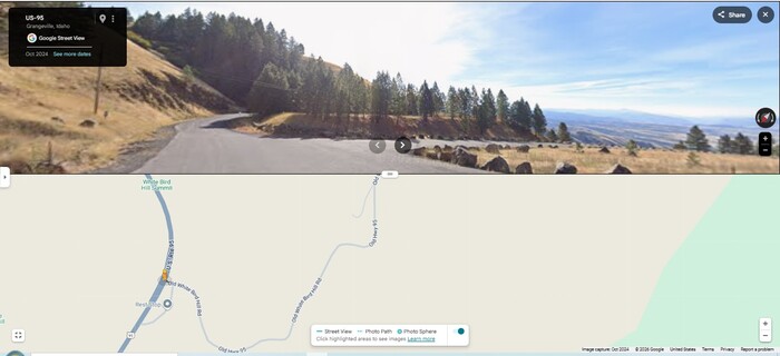
The /\Above/\ Google Street View Shows The Turnoff From The NEWER US-95, Into A Big Rest Area Parking Lot, Which Is Shown In The Next Photo Panorama.
And, Left Of Center, You See Pavement Curling Around To The Right, And Disappearing Into Trees. This Is The Older US-95, Called White Bird Grade, And Continues Northeast, All The Way Up To The West Side Of Grangeville ID.
Near Waypoint 281, Along The NEWER US-95, About 9.1 Miles SouthWest of Grangeville, ID.
EXLANATION:
A) You Can See, The Turnout Pavement Goes To The Right Between The Two Rows Of Rocks, which in turn leads to the Big Rest Area Parking Lot, which Is shown in NEXT Photo Panorama. .
B) You Can Also See Left Of Center, The Pavement That Goes Between The Roadside Brown Grass, and Then Curves To The Right, Going Along The Base Of The Barely Visible Mountain Side, Seen Just Left Of Center Screen.
C) In Strip Map Of /\ABOVE/\ GSV Photo, You Can See Old White Bird Rd, Which Is Older US-95, and continues to the Northeast, All The Way Up To The West Side Of Grangeville ID. This is the road from Grangeville, and part of the road that Robert Pirsig would have followed in 1968.
File = ScrnCapt GoogStVu US-95PatrWyDnWhBird FstBigParkLot SeeBitOldUS-95+StMapBttr1.jpg