July 2024 Added:
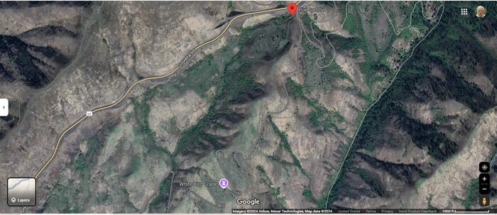
A Google Satellite View Shows => At Top A Red Pinpoint, Which Marks The Poe Saddle (Waypoint 281b, GPS 45.825390, -116.238183.)
And The Landscape Topology Of The Poe Saddle, Made It Relatively Easy To Create A Turn-Off FROM The Newer US-95, ONTO Where You Can Drive Onto The Older US-95.
And Then, Continue Down (Where, On The /\Above/\ Satellite View, Your See Wprds > White Bird Grade.) Where After About 15 Switchbacks, You Will Eventually Reach The Small Town Of White Bird, ID.
********************
Saturday, July 20, 2024:
When David & I, Henry Gurr, Were Here, We Looked Very Closely, AND Entirely Missed, the turn-ooff that would lead to the road of The Narrators 1968
I see our road will go down and down through what must be a hundred hairpin turns
.
Poe Saddle, Along The Newer US-95, About 10.2 Miles SouthWest of Grangeville, ID.
SINCE IT IS EASY TO MISS =>
AN INTERLUDE TO EXPLAIN => WHEN TRAVELING DOWN THE NEWER US-95 => WHERE & HOW TO TURN ONTO THE OLDER US-95.
FIRST:: In the /\Above/\ Satellite View, you see at top the Red Pinpoint at Poe Saddle, Which Shows EXACTLY Where Along The Newer US-95, You Can Drive Onto A Portion Of The Older US-95, And Continue Down Along White Bird Grade. After About 15 Switchbacks, you will eventually reach the Small Town of White Bird, ID.
SECOND:. Click Here To See The Above Satellite View, And Be Able To Zoom In For Closer Look,-. . OR
THIRD: To see BOTH the Narrators old twisty hairpin curved Road and The Newer Highway, US-95, on a Topographic (Topo) Map, Click Here => RIGHT CLICK AND SELECT NEW TAB => AFTER Map View Comes Up, You Will See Adverts That Cant Be Eliminated => YOU BEST SHOULD => ..
.Use Scroll Bar At Far Right => Adjust Green Topo Map Until You See JUST BELOW The Plus&Minus At Upper Left => A ClickOn For Full Screen. Click On It. => >
.Then use Plus&Minus To Zoom. You can Click&Drag Map In Any Direction, To See More Off Your Screen Edges.
..****************..
THIRD CONTINUED: Once The Next Above Blue Link Is Up, And Clicked For Full Screen, You Should Be Able To See =>
A) At Far Left the Blue Salmon River along which further South, The ZMM Route, on US-95 will follow.
B) At center, The Nez Perce National Historical Park, surrounded by a Bold Red-Brown Border.
C) A bit left of the Bold Red-Brown Border, the Narrow Dark Line is the Newer Highway, US-95..
D) Just Right of the Upper Part of the Border, you will see Narrow Double Line of the older US-95, which is the Narrators road =>
I see our road will go down and down through what must be a hundred hairpin turns
.
E) Close study of either end of the Narrow Double Line, should reveal how to find, the connecting road(s, needed to actually access & travel the Narrators old twisty hairpin curved road.
.****************..
FOUTRH: Make a paper printed topo map, and with this map in hand, it should be easy for you to find, the needed road(s), to do this.
..****************..
FIFTH: The Following Photo Of Googe Street View, You Can See At Left Blue Line Which Is Newer US-95, And Below Poe Saddle, You See Words Old Highway 95 Which Is The Older US-95.
.****************..
SIXTH:
The 2nd next photo will additionally discuss the Narrators Road to White Bird Hill using the old twisty hairpin curved road. File = ScrnCaptGoogSat PoeSaddleRedPinPoint45.825390 -116.238183HoToGoOnOldUS95.jpg
.****************..
SEVENTH:
For more discussion of how David Matos & Henry Gurr missed the turn off at Poe Saddle, please go 7 photos below and read after A Panorama View Of Approximately Tier 9 Of The 21 Tiers
.
File = ScrnCaptGoogSat PoeSaddleRedPinPoint45.825390 -116.238183HoToGoOnOldUS95.jpg