Saturday, July 20, 2024:
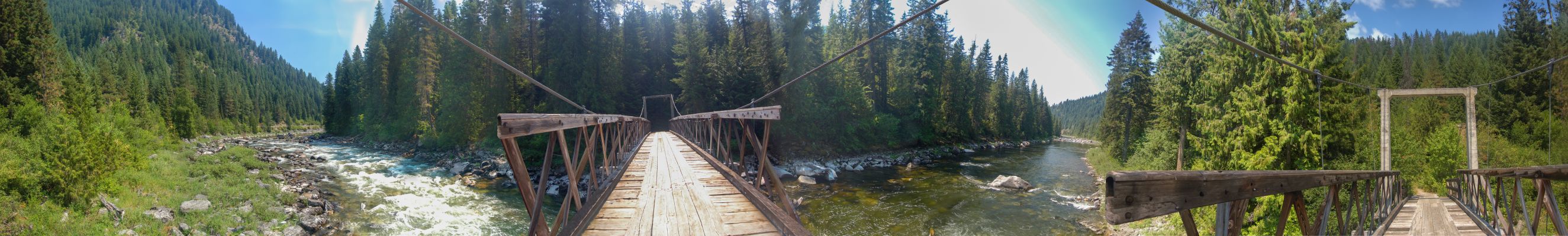
A Panorama View Over The Lochsa River, From The Center Of A Suspension Bridge.
At The Panoramas Left End, To Left Of The Water, You Can See The Straight Line Of The Highway, And Above See How Steep & Deep Is This Rivers Canyon Here.
Google AI Finds This =>
The distance from Colgate Lick Turnout, to the Mocus Point Trailhead & Bridge, is approximately 9 miles West by river, and it's considered a beginner whitewater run on the Lochsa River, starting near the Colgate dispersed camping area and ending around the Mocus Point Pack Bridge area.
ABOVE PHOTO VIEWING NOTE =>
In The Above Panorama, yours truly did not take enough Photos Before & After The Suspension Bridge. As a result the parts of the Side Rails Of The Bridge are not all there. But despite this, you can still feel the essence of what it is like to be here looking over the rivers charging rapids!
Mocus Point Trailhead, US-12, Lochsa River Canyon, ID.
***************
Saturday, July 20, 2024:
Mocus Point Trailhead.
Fourty-six miles northeast of Lowell, at milepost 143 along the Northwest Passage Scenic Byway and All American Road (US Highway 12), visitors can witness the magnificent Mocus Point Suspension Bridge [and Nature Trail] leading into the Selway Bitterroot Wilderness across the Lochsa River. Spacious parking, hitchrails, stock ramps and a restroom provide for a comfortable unloading zone whether you are stopped for a break from your drive or preparing for a long pack trip into the wilderness.
This National Forest WebPage has a map showing how to get here, and surrounding area. Click Here.
The Lochsa River Is Wild And Remote. August 7, 2022.
The Lochsa River is wild and remote. After Lewis and Clark crossed Lolo Pass they continued westward (generally) following the Lochsa River. The Lochsa River headwaters start north of Lolo Pass flowing to the west. On both the north and the south banks of the Lochsa River there is a dense forest. When Lewis and Clark followed the trail it was only a path used only by Native Americans and wild animals. The Lewis and Clark route was 160 miles long.
This Forest Travel WebPage has 13 good large photos, several of which show this Bridge, and The River & the Mountains. Click Here.
Lochsa River Historic Trail, USDA Forest Service Backcountry Trail.
This National Forest WebPage has a map showing how to get here, and surrounding area. And 3 photos, one of which in the Lochsa Historical Ranger Station. Click Here.
File = DSC 0683 (1)Pano SuspensionBridgeLochsaRiver Resize2649x400
