Monday, July 22, 2024:
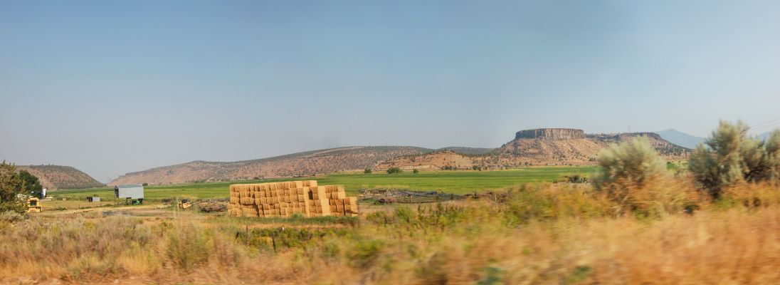
A Second General Panorama View Of The Valley Of The Crooked River: The Big Stack Of Hay (Or Straw) Shows How This Wide, Flat, Valley, Is Fertile and Agriculturally Productive.
From Wikipedia More Information About => Ancient Volcanic Lava Formations Are Seen All Over Oregon State, And Southern Washington State.
Formation.
Sometime during a 1015 million-year period, lava flow after lava flow poured out of multiple dikes which trace along an old fault line running from south-eastern Oregon through to western British Columbia.[citation needed] The many layers of lava eventually reached a thickness of more than 1.8 km (5,900 ft). As the molten rock came to the surface, the Earth's crust gradually sank into the space left by the rising lava. This subsidence of the crust produced a large, slightly depressed lava plain now known as the Columbia Basin or Columbia River Plateau. The northwesterly advancing lava forced the ancient Columbia River into its present course. The lava, as it flowed over the area, first filled the stream valleys, forming dams that in turn caused impoundments or lakes. In these ancient lake beds are found fossil leaf impressions, petrified wood, fossil insects, and bones of vertebrate animals.[5][6]
,,,In the middle Miocene, 17 to 15 Ma, the Columbia Plateau and the Oregon Basin and Range of the Pacific Northwest were flooded with lava flows. Both flows are similar in composition and age, and have been attributed to a common source, the Yellowstone hotspot. The ultimate cause of the volcanism is still up for debate, but the most widely accepted idea is that the mantle plume or upwelling (similar to that associated with present-day Hawaii) initiated the widespread and voluminous basaltic volcanism about 17 million years ago. As hot mantle plume materials rise and reach lower pressures, the hot materials melt and interact with the materials in the upper mantle, creating magma. Once that magma breaches the surface, it flows as lava and then solidifies into basalt.
Transition to flood volcanism
In the Palouse River Canyon just downstream of Palouse Falls, the Sentinel Bluffs flows of the Grand Ronde Formation can be seen on the bottom, covered by the Ginkgo Flow of the Wanapum Basalt.
Prior to 17.5 million years ago, the Western Cascade stratovolcanoes erupted with periodic regularity for over 20 million years, even as they do today. An abrupt transition to shield volcanic flooding took place in the mid-Miocene. The flows can be divided into four major categories: The Steens Basalt, Grande Ronde Basalt, the Wanapum Basalt, and the Saddle Mountains Basalt. The various lava flows have been dated by radiometric datingparticularly through measurement of the ratios of isotopes of potassium to argon. The Columbia River flood basalt province comprises more than 300 individual basalt lava flows that have an average volume of 500 to 600 cubic kilometres (120 to 140 cu mi).
The transition to flood volcanism in the Columbia River Basalt Group (CRBG), similar to other large igneous provinces, was also marked by atmospheric loading through the mass exsolution and emission of volatiles, via the process of volcanic degassing. Comparative analysis of volatile concentrations in source feeder dikes to associated extruded flow units have been quantitatively measured to determine the magnitude of degassing exhibited in CRBG eruptions. Of the more than 300 individual flows associated with the CRBG, the Roza flow contains some of the most chemically well preserved basalts for volatile analysis. Contained within the Wanapum formation, Roza is one of the most extensive members of the CRBG with an area of 40,300 square kilometres and a volume of 1,300 cubic kilometres. With magmatic volatile values assumed at 1 - 1.5 percent by weight concentration for source feeder dikes, the emission of sulphur for the Roza flow is calculated to be on the order of 12Gt (12,000 million tonnes) at a rate of 1.2Gt (1,200 million tonnes) annually, in the form of sulphur dioxide (SO2). However, other research through petrologic analysis has yielded SO2 mass degassing values at 0.12% - 0.28% of the total erupted mass of the magma, translating to lower emission estimates in the range of 9.2Gt of sulfur dioxide for the Roza flow. Sulfuric acid, a by-product of emitted sulfur dioxide and atmospheric interactions, has been calculated to be 1.7Gt annually for the Roza flow and 17Gt in total. Analysis of glass inclusions within phenocrysts of the basaltic deposits have yielded emission volumes on the magnitude of 310 Mt of hydrochloric acid, and 1.78 Gt of hydrofluoric acid, additionally.
Cause of volcanism
Major hotspots have often been tracked back to flood-basalt events. In this case the Yellowstone hotspot's initial flood-basalt event occurred near Steens Mountain when the Imnaha and Steens eruptions began. As the North American Plate moved several centimeters per year westward, the eruptions progressed through the Snake River Plain across Idaho and into Wyoming. Consistent with the hot spot hypothesis, the lava flows are progressively younger as one proceeds east along this path. Previous to this eruptive period, it is believed the Yellowstone Hotspot created features like Smith Rock in Central Oregon and perhaps another flood basalt event known as Siletzia which underlies much of the Pacific Northwest coast with exposures in the Oregon Coast Range.
There is additional confirmation that Yellowstone is associated with a deep hot spot. Using tomographic images based on seismic waves, relatively narrow, deeply seated, active convective plumes have been detected under Yellowstone and several other hot spots. These plumes are much more focused than the upwelling observed with large-scale plate-tectonics circulation.
File = DSC 0523 PhotoSetOfHGUpLdJan142025 2ndPanoFarmValleyCrookedR Resize1096x400
