Sunday, July 21, 2024:
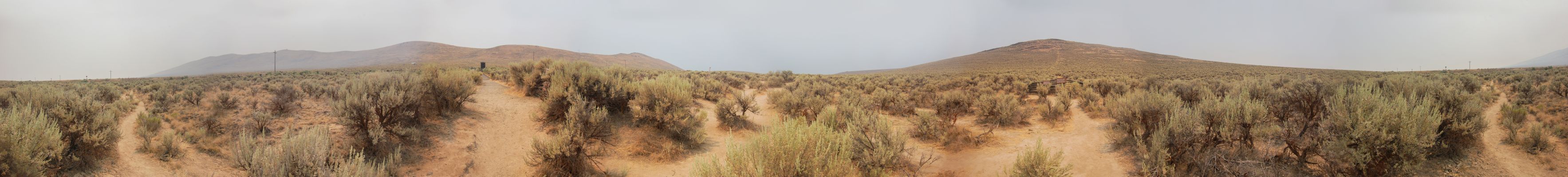
A Panorama Showing The Sagebrush Scene, Like That Which =>The Oregon Trail Emigrants Would Have Seen When They Came By Flagstaff Hill.
As Explained In Previous Photo => Along Rt-86, A Sign Tells Traveler, That They Can See The Historic Oregon Trail Ruts!, By Going Thru The Turn-style Gate, And Walking Northeast ~200 Feet, Along The Path, With The Clear Inference That The Ruts Would Be Obvious.
However, Henry Gurr Completing These Instructions, Did Not Find Any Ruts
This Is Because The High Sagebrush, Makes It Quite Hard To Identify Ruts, When Over 20 Feet Away. And Later, Henry Belatedly Found That He Did Not Walk Far Enough, About 40 feet.
HENCE THE /\ABOVE/\ PANORAMA SHOWS =>
.A) A Scene Similar To What The Oregon Trail Emigrants Would Have Experiences, When They Came Through Here. And
.B) Scrolling /\Above/\ Panorama To The Right, Until You See The Highest Hill: This Is Flagstaff Hill.
.C) And, Below Flagstaff Hill, Rather Small, You See Wooden Rails (About 40- Feet Away), With A Sign, Which Belatedly Henry Learns, Tells Where To See The Ruts!
***********************
NOTE: Although the Ruts are sometimes hard to find here, there are places where the ruts, even gouges, left by passages of the huge number of wagons, left far more evidence, still visible today. In one place, there is a deep trench deep & wide enough to bury a semi-truck on its side!
Click Here, To See Evidence Of This And SIX Of My Other 2002 Oregon Trail Photos. Please Start Here.
File = DSC 0417 (1) PanoOregonTrailRutsAreaOverview Resize3534x400