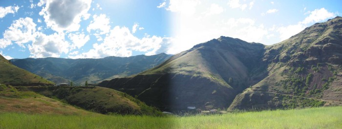
White Bird Creek Has, By Eons Of Erosion, Literally Cut Thru The Closer Black Volcanic Rock Mountains, As It Flowed To Join The Salmon River & Canyon, Further Southwest.
In 1968, Robert Pirsig & Chris Likely Followed Older US-95, Which With White Bird Creek, Is At Bottom Of The Canyon (Below Level Of View), Seen Beyond The Green Grass Foreground.
From Here, They Traveled Further Southwest, About A Mile, Into The Even Deeper & Far Larger Salmon River Canyon, Which Is Unseen, Before The Base Of The Most Distant Mountains.
The ZMM Narrator Says =>
. the road
. then proceeded on to a big fast river, the Salmon,
. (Cont. Next)
One mile South of White Bird, ID.
As mentioned in the previous Photo Caption, the Narrators 1968 road (Older US-95), and White Bird Creek are in the deep canyon, as they go through White Bird town center. This is where the best photos would have been.
In two miles (Upcoming Photos), the view changes dramatically, as we take the new road into the Salmon River Canyon, which will be at the hidden base of the far distant mountains /\ Above /\ Photo.
. Again, you should recognize black volcanic rock. I have the impression that the previously mentioned volcanic flow, which covered one quarter the combined area of Idaho, Washington, and Oregon, is the biggest ever!!! It is said to have fill up 40,000 cubic miles!! See Blue Link Below =>
... This Discussion & Geology Volcano Flow Maps Are Interesting. Click Here.
**************************
(Photo = 111-1129 + 1sc ...... ZMM Page = 260 ...... WayPt = 283x 1732ft)