Same Camera Location As Previous Photo => But Opens With A View Southwest, Looking At The Jefferson River Valley Landscape, Then Swings To West, Away From Three Forks, MT.:
The Camera Continuing From The Previous Panorama Photo, Swings To The Right, So The Jefferson River Is (At Far Left), Out Of View.
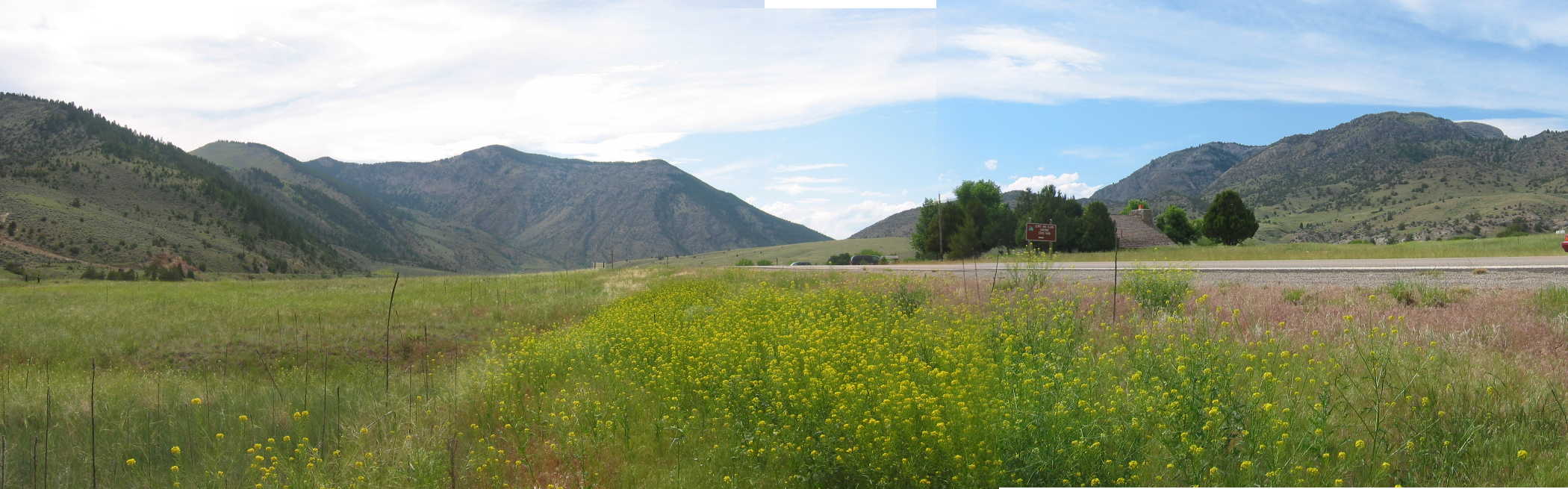
Click Photo Several Times To Get Largest View, Then. ClickDrag The Bottom Bar, Gradually Scroll This Panorama, So The Yellow Flowers Are Mid Screen, and Above the Flowers You See A V Between The Mountains, At Which Point => You Are Looking West At The Landscape Up River.
.AND The V Between The Mountains, Is The ZMM Narrators, [Where he road]
.cuts into a narrow canyon of whitish-tan rock
. This Is Because => The V Between The Mountains, Is Where The Jefferson River, Has Made An Especially Sharp & Deep-Cut Through A Magor Mountain Ridge.
Additionally, To The Right Of The V, Nested In The Clump OF Trees
. Sure Enough
. There It Is!
. Exactly The ZMM Narrators ~Brown Sign For Lewis and Clark Caves State Park !
.Continued ClickDrag Bar To Right Edge of Panorama Photo
You Are Looking North, And Will Recognize The Flowers & Highway Of Previous Photo, and SECOND Previous Photo.
..SUMMARY: These Above Descriptions, Are The Facts, All Of Which Exactly Fit The ZMM Narrative! (As In The Italics Below.)
The ZMM Narrator Says =>
[The road]
.cuts into a narrow canyon of whitish-tan rock, past some Lewis and Clark caves.
NOTE: The location of the Lewis and Clark caves, is NOT at the ZMM NarratorsThree Forks, but some 24 straight line miles West & a bit South.
Along The Jefferson River, Approaching . A Narrow Canyon Of Whitish-Tan Rock ~2 Miles SE Of, Jefferson Island, MT.
.... After leaving Three Forks, MT, my paper research notes say } Cross Jefferson River, and see Junction Rt-287, and start looking for Rt-2. Turn on it, and following upstream this one of three rivers, = The Jefferson. Later my paper research notes say what I see at the location of the /\above/\ Panorama Photo => A rodeo corral, a huge salvaged bridge truss, and Lewis and Clark Caves sign, and ahead, I see the gap where I will be entering (as the river does) the narrow canyon through the mountain ridge.
..****************..
.The /\ Above /\ Photo Introduces A Geological River Pattern, That Is Seen When Traveling Along A Road, Following A River. This Is Seen Repeatedly In Montana, AND Somewhat Happens At This Photo Location, In The Jefferson River, As Follows =>
.As a river valley is traveled, at first there may be a kind of terrace, which is level and relatively wide, with the river a meandering still water.
Ahead you can see the valley land is narrowing, then ends with the road and the river is now descending, in a narrower canyon, with rapids. This is where the canyon is narrow, the river & road are relatively rapidly descending, and thus twisty-wind down the canyon, until both begin to level out. At this point, they emerge into another level and relatively wide valley land terrace, much like the previous, with the river a meandering still water river!
The Geology Cause?
.It seems that the level, wide valley land, is held that way, against the river erosion, by relatively harder, more durable rock ridge (or rock layer), the drop-down edge of which is called a Nickpoint.
.This harder rock is preventing the land from eroding down to the same level as the lower, wide, flat valley terrace next below. Saying it differently, this strong rock has kept the upstream valley land level, and all its beautiful fertile farming, just the way it is.
To See Rather Good Example of This, With Full Discussion & Photos, Click Here
..****************..
.And Come To Think Of It => What Happens With The Three Rivers, After Three Forks, MT, Is Also A Rather Grand Example Of This!
.These rivers at first are meandering still water, then the valley is narrowing, with the three rivers now forced into one. This is followed by a narrow, deep, steep walled canyon, that is descending in white water rapids.
NEW TOPIC2:
.Because Both Author Robert Pirsig & The ZMM Narrator Hate & Despise Tourist Attractions, There Is Absolutely No Hint In ZMM, That => There Is Anything Interesting In Or About These Lewis & Clark Caves!
.But the actual Facts are Quite the Opposite!!! Click Here For Wikipedia, Which Has A Great Photo of Stalagmite Limestone Formations Inside The Cavern.
LEWIS & CLARK CAVERNS STATE PARK.
.Discover one of the most highly decorated limestone caverns in North America.
Camp, hike and experience amazing geologic wonders at Montana's first and best-known state park.
*************************
(Photo = 109-0930 +108-0923 + 109-0924sc ...... ZMM Page = 235 ...... WayPt = 232x 4308ft)