ContFmPreviousPhoto =>
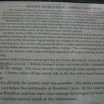
4:25 pm Mon 12 Aug: Historical Marker Sign for The Little Porcupine Creek Camp Site, One Mile North of Yellowstone River at Forsyth, MT. ((NOTE: See ..1) below, for /\ Above /\ Image Viewing Instructions.))
.Apologies for some of words missing. AND Unfortunately Google cant find useful information about this Sign or the History it relates. .Showing the /\ Above /\, does not mean that Henry Gurr at all approves of the brutal domination of this countrys Native Americans.
As you will see in NEXT Panorama Photo, The /\ Above /\ 2013 Google Street View, Space Between The Trees, Now Filled With A This /\ Above /\ Shown Historical Marker Sign. .************** .
VIEWING HINTS FOR/\ Above /\ & NEXT PANORAMA PHOTO: ..1) Remember to click photo several ties to get the biggest view, & possibly use Magnifying Glass). ..2) Because It Is So HUGE, Much Of The Image Will Be Off Screen, And You Will Need To Use Mouse-Click&Drag-Slider Bars.
. .For Additional Gallery Viewing Instructions => : A) Go Back And Read Viewing Hints, In This Albums Description. OR B)After This Link Comes Up, Scroll Down ~Midway To Album 360 Degree Panoramas And Start Reading Where Says Suggestions For Beginners Cont Next.Photo => A PANORAMA VIEW Of => View Over Irrigated Fields of Yellowstone River Valley, Near Forsyth, MT.
Photo File = DSC_0525 ForsythMT LittlePorcupineCreekCampSite. HistoricalMarkerSign Text.jpg Posted 13 Oct 2020, Revise 14 Oct & 5 Nov 2020.
| File size | : | 2430465 bytes |
| File date | : | 2020:11:05 18:15:28 |
| Camera make | : | NIKON CORPORATION |
| Camera model | : | NIKON D50 |
| Date/Time | : | 2019:08:12 18:53:28 |
| Resolution | : | 3008 x 2000 |
| Flash used | : | No |
| Focal length | : | 55.0mm (35mm equivalent: 82mm) |
| Exposure time | : | 0.0025 s (1/400) |
| Aperture | : | f/10.0 |
| Whitebalance | : | Auto |
| Metering Mode | : | pattern |
| JPEG Quality | : | 97 |