~8 am Mon 12 Aug, Bureau of Land Management Campground, Just off US Routes 12 & 287, Winston, MT. .NOTE: As you read the below, you may wish to consult ( & have up in a separate Browser Frame) => , Right Click Here &, Select New Tab, For => A Satellite View of Central Montana, Showing Roads => A) See Upper Left> Helena, MT to>Towsend, MT (Red Pinpoint) to> (un-labeled yellow line =US 12 Trending Northeast ) to> WhiteSulpherSprings, MT Then East to> Harlowton, MT to> Musselshell, MT to> Ingomar, MT to> Forsyth, MT at I-94 AND B) See at Bottom Left showing I-90, Three Forks, MT to> Bozenan, MT to>:Billings, MT. Then I-94 to. Forsysth, MT to Rosebud, MT.
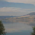
Planning Henry Gurrs Return Trip To South Carolina: Thoughts On What Roads S/B Followed: . Yesterday ~11 am, Henry left Kalispell, MT after a good visit with his brother Philip and Wife Janet. Yesterdays travel was South, to US 12, which lead through Helena, MT ( where US 12 joins & travel with US 278 ) .From Henena, Mt, US 12+278, are trending Southeast, along the Missouri River Valley to Winston, MT => For Henry, here was a convenient return, for a 2nd overnight at BLM Campground: .Sleeping well beside the Missouri River (View /\ Above /\), Henry early gets out his Montana Highway Map, to re-view the possible routes Back East, to his home in Aiken SC. ((You Dear Reader might ALSO re-view study these same routes, on Satellite View of Central Montana. which is /\ ABOVE /\ MENTIONED BLUE LINK. )) EXPLANATION => Its been 17 years since Henrys FIRST Travel of The Route In The Book Zen & Art of Motorcycle Maintenance , and today starts for Henry => A good chance to do more ZMM Route Research plus find & photograph any major changes, since 2002. Starting 1 August 2019, Henry had already traveled the ZMM Route from Miles City, MT, to Bozeman, MT, to Three Forks, MT THUS After studying maps for ~20 min Henry decided to continue ~30 miles South to Townsend, MT, then follow US 12, straight East, go over a darker green Range of Mountains (discussed next photo, called The Big Belt Mountain Range), then joining with US 89 goes north to White Sulphur Springs, MT. Then both routes follow a green valley East for ~5 miles, whereupon US 12 splits off to go generally East in semi-arid valleys, between Mountain Ranges. Then US 12 (about half way to US 191), goes by junction with Rt 294 => This Junction is the noteworthy location of TWO FORTHCOMING Gallery Photos for respectively a) Desolate Dry Lands & b) Landscape Nearly Instantly Changes To Beautiful Green of The Musselshell River Valley !! .Continuing on US 12, it finally joins into I-90 at Forsyth, MT The ZMM Route, On US 12 Goes From Forsyth, MT, To The East For ~600 Miles, Is. AND To The West For 150 Miles. .As may be seen on Maps, The ZMM Route on US 12 goes from Forsythe, MT (in Eastern Montana), goes East into Central South Dakota (~600 miles). AND in the opposite direction, The ZMM Route on US 12 goes from Missoula, MT (Western Montana) to well into Idaho (~150 miles). .Plus The ZMM Route goes ~80 miles on US 212, from Laurel, MT, to Yellowstone National Park. There are hints that US 212, has a tangled history with US 12. ((You will eventually come to appreciate that => US 12 is a historical & rightly famous route, for kinds of reasons, as you will see in ~ 6 of the forthcoming photos of this Album. ))
Cont Next.Photo => A Satelite View & Notes Concerning The Geology & Geography of Southern Montana, That Also Shows Part of Henry Gurr Route Of Travel.
Photo File = DSC 0317 BLM Campground View Missouri River Posted 28 Apr 2020, Revise 6 May & 12 July & 5 Nov 2020.
| File size | : | 2673168 bytes |
| File date | : | 2020:04:28 21:24:23 |
| Camera make | : | NIKON CORPORATION |
| Camera model | : | NIKON D50 |
| Date/Time | : | 2019:08:06 20:50:29 |
| Resolution | : | 3008 x 2000 |
| Flash used | : | No |
| Focal length | : | 55.0mm (35mm equivalent: 82mm) |
| Exposure time | : | 0.0031 s (1/320) |
| Aperture | : | f/9.0 |
| Whitebalance | : | Auto |
| Metering Mode | : | pattern |
| JPEG Quality | : | 98 |