At Laurel, in sight of the mountains
.Beyond those buildings are mountains and snowfields.
Sylvia says John has talked to someone in town about another route to Bozeman, south through Yellowstone Park.
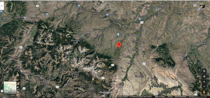
.TO HELP YOU UNDERSTAND THE LANDSCAPE CONTEXT OF THE REMAINING 150 PHOTOS OF THIS ALBUM =>
.PLEASE STUDY THE /\ ABOVE /\ SATELLITE VIEW OF SOUTH CENTRAL MONTANA:
.Upon Which You Can See The ZMM Route As Follows =>
..A) Top Right Corner, The ZMM Route (Coming from Miles City, MT) Comes Into This Satellite View at where you see I-90, to Billings, MT.
..B) At Top (Right of Center), you see US-212 & The Dark Green of Rock Creek, which is ZMMs We are following a creek to its source.
This is where => The ZMM Route, follows both of these, from Laurel, MT, through Red Lodge, MT, and Into The base of the White Show Covered Absaroka Range of Mountains.
..C) The ZMM Route leaves Rock Creek, at midway between the two US-212 Icons SW of Red Lodge, Mt: AND thereafter follows US-212 through Cook City, MT & East Gate, MT, to The North East Gate of Yellowstone National Park..
..D) At The North East Gate of YNP, US-212
having served its Original National Purpose
Officially Ends. AND on YNPs own road, The ZMM Route continues West To US-89.
..E) Where-After The ZMM Route Follows US-89 Thru Gardner, MT, To Livingston, MT, and then follows I-90 West To Bozeman, MT.
****
..F)- PLEASE NOTE1 => With The Exception of Billings, MT, The above mentioned towns are featured in ZMM Book, and thus are ZMM Route Towns
..G). PLEASE NOTE2 => In the /\ Above /\ Satellite View => The Dark Green is Clarks Fork of The Yellowstone River, From Rockvale, MT to Clark MT. This major river is mentioned in Forthcoming Photos.
*********************
DATE-LINE: MARCH, 7-18, 2021. by HENRY GURR.
..THE FULL GENERATIVE STORY OF AN IDEA COME TO FRUITION ! =>
. THE WHY Of => The /\ Above /\ Satellite View,
..AND HOW => The Ideas For IT Gradually Emerged =>
****
In The Process Of My Composing The Words For The Descriptive Captions For These Two Upcoming Photos =>
..A) The Finn Ditch Irrigation Canal, and
..B) The Water Birch, Montana State Fishing Access & Camping Site..
.**************
I FOUND IT NECESSARY HERE => TO USE SATELLITE VIEWS, TO HELP PICK-OUT THE EXACT LOCATION, AND EVEN THE OFFICIAL NAMES OF, WHAT WAS SHOWN IN THESE TWO A) & B) PHOTOS
..1) AND from this I realized (AHA !!) you the reader ALSO need to see this same CLOSE-UP Satellite View. =>
..2) AND as I was adjusting (and Zooming Out to lower magnification), I realized (SECOND AHA !!) you the reader in ADDITION needed to see A GENERAL SATELLITE OVERALL VIEW of The Montana ZMM Route Roads, and thus Understand The Landscape Context Of The Remaining 150 Photos Of This Album.
**************
..3) SO, THERE YOU HAVE IT => The Origins Of The /\ Above /\ Satellite View!
..4) AND THEN WAS REALIZED (THIRD AHA !!) the added virtue , that this same Satellite View can nicely Be Your Own Starting Point (following Blue instructions below) to DO your OWN Zoom Into This Detailed Satellite View, to exactly show you the Close-Up Terrain Lay-Out for the Above-Mentioned Two Photos of A) and B),
..5) Of course, you will need to => Keep In Mind that => The Center of Screen Red PinPoint, Marks the Location of these Mentioned Two Photos of A) and B) Above.
. RIGHT CLICK AND SELECT NEW TAB =>
. And after Satellite Map View Comes Up, You will See ~ ZMM Route As Spelled-Out In Bold Title Just Under /\ Above /\ Satellite Photo. ((SIDE NOTE => You can ClickOn The Plus&Minus To Zoom. You can also Click&Drag Map In Any Direction, to See More Off Your Screen Edges.))
Now, Keeping In Mind =>
..a) The Red Pinpoint Marks Henry Gurrs Above-Mentioned Two Photos of A) and B) .
..b) You are now ready to use this Satellite View, so you can see A Close-Up Satellite View of WHERE These Two Photos of A) and B) were taken.
..c) To do this => Click the (( Plus )) and Zoom-In-To-Near-Max, keeping The Red Pinpoint Marker at Center of screen, AND => Along US-212. Halfway between Roberts, MT, & Fox, MT, you will see =>
.i) On BOTH Sides of US-212 => The Finn Ditch Irrigation Canal, and
.ii) On East Side of US-212 => The Whitish Side-Road, that access to the Parking Lot For Water Birch, Montana State Fishing Access & Camping Site. This Side Road is inter mixed with the trees surrounding Rock Creek.
..d) These i) & ii) above, are the Topics of FIVE Forthcoming Photos.
*************************
(Photo =. GoogSat I90Bozeman}Billings US212Laurel}WaerBirchFishAc}RedLodge}YNP US89Livingston.jpg ..... ZMM Page = 104-105 ...... WayPt = NA )