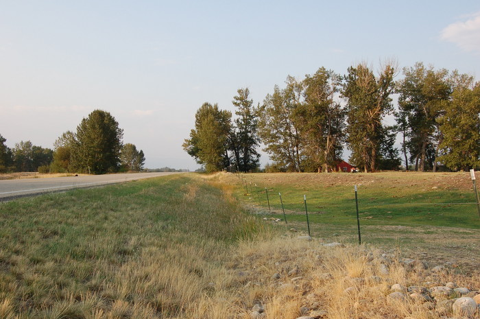
Shade Trees Along The highway: Looking SSW Along US-212 Towards Red Lodge, MT.
..Stopping Here Because A Sign Fishing Access, Leads To Investigating /\ Above /\ Photo Scene. =>
..The Narrator Repeatedly Mentioned Following a Creek To Its Source.: But Where Is The Stream?
.We are following a creek to its source. It contains water that was probably snow less than an hour ago. The stream and the road pass through green and stony fields each a little higher than before. Everything is so intense in this sunlight. Dark shadows, bright light. Dark blue sky. The sun is bright and hot when were in it, but when we pass under trees along the road, its suddenly cold.
The /\ Above /\ Photo is along US-212, .5.0 Miles WestSouthWest from Joliet, MT, with another 9.2 miles to Red Lodge, MT. All the time I drove SSW on US-212 from Laurel, MT (June 2002), I was mindful of the above ZMM Passage, and kept looking for a creek , but mostly couldnt find it!
.Youll have to understand that => Im from ~wet-lands Ohio with plentiful rain and trees everywhere. So only after many missed photo opportunities, did I slowly & eventually did I learn* & get into my bones that => In the dry arid lands such as Montana, ANY concentration of trees (as in the /\ Above /\ Photo), MEANS water of a stream, a canal, or river, practically.!!
.Traveling Southwest From Laurel, MT Along Us-212, The ZMM Traveler, Looking Carefully, Will See Rock Creek => Is East. of highway, and then, just 1.5 mile Southwest of Joliet, MT, ( at an easy to miss bridge), crosses to the North, and then the Northwest side of the highway..
.Continued traveling Southwest along US-212, the ZMM Traveler, looking carefully, now will see Rock Creek is Northwest of highway: And then 6.4 Southwest of Boyd, MT= WayPt = 124.(at an easy to miss bridge), crosses to the Southeast side
.These two creek-crossings somehow, escaped my attention: Was this because Rock Creek has already been greatly depleted by the numerous irrigation canals, or too much obscured by trees?
.Thus, at two places (after Joliet, MT & after Boyd, MT, I actually crossed over Rock Creek, but failed to recognize Thats what I was looking for! Thus I twice missed my Photo Op!!
.I was hardly any better on my trip Sept 2006. I again missed BOTH of these crossings, and got another ~5 miles all the way to /\ Above /\ Photo location, until I first found a place to get photos of Rock Creek!
.SIDE NOTE: In /\ Above /\ Photo, looking SSW towards Red Lodge, MT, Rock Creek is to the left, which is East of the highway, and remains so until (another easy to miss), crossing, 5.2 miles SW of Red lodge, MT.
.As the ZMM Narrator says => The facts are there but you dont see them. Youre looking right at them, but they dont yet have enough value.
.In The Photo /\ Above /\ Photo, The Line Of Trees On Both Sides Of The Road, Mark An Irrigation Canal. This Canal, Finn Ditch, Gets Its Water From Rock Creek, which here is on the left (East) of the road. Here Rock Creek is located in a similar line of trees, as will be seen in the Next Photo. More examples will be in Four Forthcoming Photos.
.SUMMARY => In this dry climate, trees would pretty much NOT be here, as is shown in /\ Above /\ Photo, without a stream, a canal, or sponsorship of humans. The ZMM Traveler needs to learn how to look, and see where the water is, as discerned from a concentration of trees, from here, all the way on into Red Lodge, MT.
How To See A Satellite View **AND** A TopoZone Map of My /\ Above /\ 2006 Photo Location At WayPt = 124. This WayPt Is About Halfway Between Roberts, MT, and Fox, MT, which are about 7 miles apart.
.A) To find & study a Satellite View RIGHT CLICK AND SELECT NEW TAB => After Satellite Map View Comes Up, You will See (again the previously displayed => SATELLITE VIEW OF SOUTH CENTRAL MONTANA, which had => ) ZMM Route along US-212, SW of Laurel, MT, on way to Red Lodge, MT. The Red Pinpoint marks my Photo WayPt = 124. => ClickOn The Plus&Minus To Zoom. You can Click&Drag Map In Any Direction, to See More Off Your Screen Edges.
.B) To find & study a TopoZone Map Of Same Area As Above-Mentioned Satellite View =>
. => RIGHT CLICK AND SELECT NEW TAB => After Map View Comes Up, You Will See an AWFUL Clutter of Adverts That Are Impossible To Eliminate => YOU BEST SHOULD =>
.Use Scroll Bar At Far Right => Adjust Green Topo Map Until You See JUST BELOW The Plus&Minus Upper Left. => A ClickOn For Full Screen. Click On It, and Adverts Will Be GONE. =>
.Then use Plus&Minus To Zoom. You can Click&Drag Map In Any Direction, to See More Off Your Screen Edges..
.Topozone map shows US-212 stays quite near Rock Creek, a snowmelt stream, all the way from Laurel to the snowfields. In fact, you will see on the map that the highway stays in the valley "flood plain" between the fairly high bluffs. This map shows Rock Creek is East of the highway within 0.4 miles from the creek-crossing (South of Roberts, MT.) all the way thru Red Lodge, and well into the mountain canyon, where it again changes sides.
.Click the + to Zoom-In, and you will see, center of screen, along US-212 => Halfway between Roberts, MT & Fox, MT, The Finn Ditch irrigation Canal, AND the dotted side-road, which is the Parking Lot For Water Birch, Montana State Fishing Access & Camping Site. This is Topic of Next 3 Photos.
************************
(Photo = Summer2006 0405 ...... ZMM Page = 105 ...... WayPt = 124i ~4500ft.)