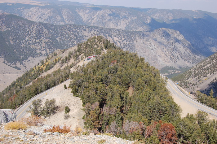
Now We Are On The Next Tier Up & Looking Back Down At the Previous Rest Areas Parking Lot
.You Can See the ZMM Narrators Little Path.
Which Is Leading Out To (Look Close) The Rocky Promontory Of The =>
Rock Creek Vista Point Viewing Platform Area.
. He would use this route to get into the high country, then backpack in from the road for three or four or five days, then come back out for more food and head back in again, needing these mountains in an almost physio-logical way..
On The Next Tire Up, AFTER Rock Creek Vista Point, First Roadside Rest Area, Beartooth Highway ~14 Miles South of Red Lodge, MT. : After leaving the Vista Point Parking Lot, The /\ Above /\ Photo was taken AFTER ~0.6 Mile, A Hairpin Switchback, and ~0.5 Miles Come-Back
Look Closely and you will see the Little Path. all the way to the end of the Rocky Pinnacle Promontory!
. To get the largest and best view, you may need to click twice on the photo.
AND With the largest view, you can see Blue, Red, & Yellow People on it. AND You can see why this Rocky Promontory Rock Creek Vista Point Viewing Area gives Such A Dramatic View! In All Directions!!
. It Is Interesting To Compare A Satellite View With The /\ Above /\ Photo.
After You Click On the Blue Link Below =>
...A) THEN Zoom Out and This Satellite View Will ALSO Help You Understand The Landscape Context Of The Next ~30 Photos Of This Album =>
...B) And After You ZOOM Out => Please Study The Satellite View Of US-212, Which Travels The Absaroka Range & Beartooth Mountains of South Central Montana:
.You Can ZOOM OUT To See The ZMM Route Marked by US-212 => ALL THE WAY through Cook City, MT. & East Gate, MT to The North East Gate of Yellowstone National Park..
.. US-212, having served its Original National Purpose, ends At the North East Gate of Yellowstone National Park (YNP).
To Study This Satellite Map, Click Here.
*************************
(Photo = Summer2006 0033 ...... ZMM Page = 110 ...... WayPt = 135t)