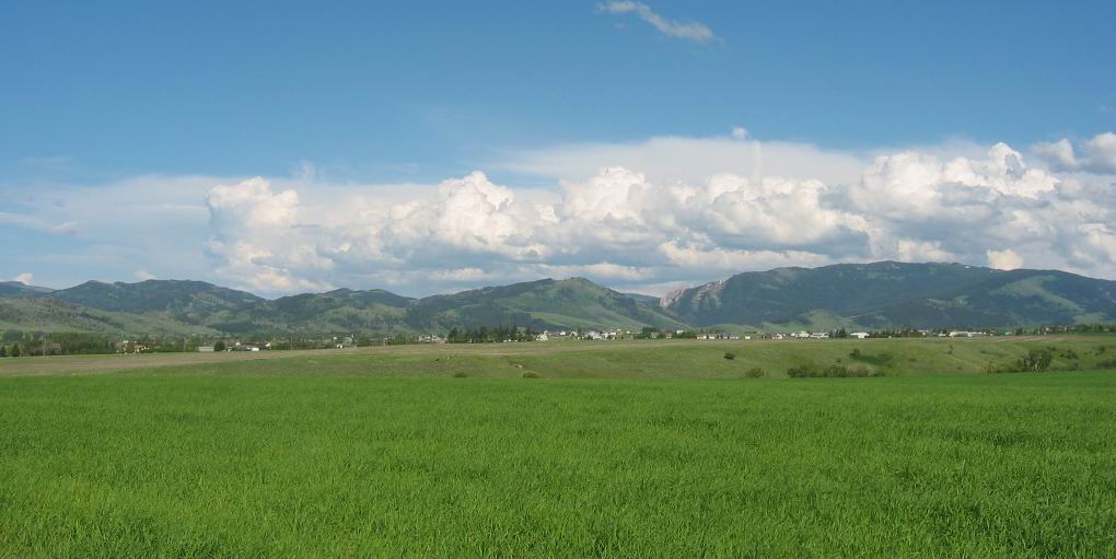
The Green Valley Where In ZMM It All Happened.
.In The Distance, The Bridger Mountain Range.
Although Bozeman Pass Is Out of View To The Left, Its Crack In The Mountains Looks Just Like The Low Place In Horizon Center.
. We ride down out of the pass onto a small green plain. To the immediate south we can see pine-forested mountains that still have last winters snow on the peaks. In all other directions appear lower mountains, more in the distance, but just as clear and sharp. This picture-postcard scenery vaguely fits memory but not definitely. This interstate freeway we are on must not have existed then.
East side of Bozeman, MT.
..****************..
Despite Robert Pirsigs 1968Trip Statement, He Must Have Used The Interstate, Because Reasonable Higher Quality Alternates Were Not Available.
In the beginning of ZMM Chapter 14, as they ride into Bozeman, MT, The Narrator says This interstate freeway we are on must not have existed then. [When Phaedrus was teaching 1959-1961]. But by 1968, and the Narrators trip, the USA Interstate Highway System was generally complete. AND in Montana => The Montana Highway Departments OWN Maps, show by year 1960, that the Montana Interstate Highways were completed. Click Here. For example => These maps show as completed => I-94 from the North Dakota Border thru Miles City, MT, to where it ends merging with I-90 In Billings, MT. And I-90 continues through Butte, MT to the Idaho Border
.From this we can conclude this is one of the VERY few places where Mr. Pirsigs Interstate Highway memory back from his time at MSU, is not correct.
..****************..
DATE-LINE: Sept 23, 2021, by Henry Gurr.
From ZMM, It Is Not Clear How Much The Narrator Could Travel Non Interstate, In Montana, However Much He May Have Wanted To.
.Along the ZMM Route, there are many places where Mr. Pirsig would have had a choice whether or not to use The Interstate. But In many places there are no other reasonable choices. For Examples see A) & C) => .
..A) Traveling West from Miles City, MT would initially have to be on I-94. But at Rosebud, MT, going West on Old US 10, would be likely be a very good road choice through to Hysham, MT.
..B) After Hysham, MT, the alternates to the Interstate are some longer secondary paved roads, which eventually get back to I-90 at Custer, MT Study your map for good choices => 1) Some connecting roads on North Side of Yellowstone River, OR 2) Paved road going SW from Hysham, MT.
..C) Going West from Custer, MT =:> The Interstate Marginal Roads (Some likely Old US 10), are available all the way through Billings, MT to Laurel, MT.
..********..
.Back in 2002, I did my best to find Non-Interstate: BUT back at that time, I did not realize that I should have started traveling West onto Old US 10 at Rosebud, MT. Thus I failed to photograph many sights likely seen by Narrator, Chris & Sutherlands in 1968.
..****************..
Overall, Henry Gurrs 2002 ZMM Route Photos Show And Discuss Roads ZMM Narrator Likely Traveled => :
:Right Click And Select New Tab. AFTER Gallery Comes Up => SCROLL DOWN TO LAST Album => ZMM All 4 Parts. => Read Description, and ClickOn Small Photo, AFTER 4 SubAlbums Page Come Up => Most Especially ClickOn Album Part II => And AFTER the Page Of 18 Small Photos Comes Up, you will be able to see Photos & Information for Mile City, MT, and ZMM Route Further West. .
..****************..
.The /\ Above /\ Photo is part of a 360 Deg Full Circle Panorama, That Shows Mountains All The Way Around Bozeman, MT.
. RIGHT CLICK AND SELECT NEW TAB => The Page that comes up shows 5 Albums => Please read the Description of TOP Album, Then Click on The Photo => AFTER a page of 9 Small Narrow Strip Photos Comes Up => AT TOP CLICK ON THE.>2< TO GO TO SECOND Page of 9 Small Narrow Strip Photos. After This Comes Up => THEN Read Upper Center, The Second Narrow Strip Photos about View Of Bozeman From East Side Of Town => THEN Click on the Narrow Strip Photos and then Click a SECOND Time to Get the Largest Panorama View, Which Is About 7 Feet Wide!
.You can Click&Drag the Sliders at Bottom & Right, to See Parts Off Your Screen Edges.
..****************..
This Google Street View (GSV) ALSO Shows The Crack In The Mountains Where Bozeman Pass & I-90 => Goes Between The Bridger Mountains To The North (Lett) and The Gallatin Mountains To The South (Right).
NEW TOPIC: RIGHT CLICK AND SELECT NEW TAB =>
.AFTER This GSV Comes Up, It Should Already Be At Max Zoom & Magnification So You Better See Distant Details.
.INSTRUCTIONS =>After Google Street View (GSV) Comes Up, at any time you can Click On The Plus & Minus, To Zoom AND You can ClickDrag the Image On Screen in any direction for a Better Panorama View.
*************************
(Photo = 106-0808c ...... ZMM Page = 136 Start Chapter 14. ...... WayPt = 193w)
