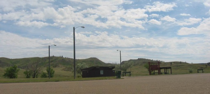
The Route 12 Roadside Stop Mentioned in ZMM.
"Before long, a roadside stop Ive been waiting for appears. A few benches, a little building and some tiny green trees with hoses running to their bases. John, so help me God, is at the exit on the other side, ready to pull out onto the highway. .. I ignore this and pull up by the building. Chris jumps off and we pull the machine back up on the stand. The heat rises from the engine as if it were on fire, throwing off waves that distort everything around it. Out of the corner of my eye I see the other cycle come back. When they arrive they are both glaring at me. .. Sylvia says, "Were justangry!" .. I shrug my shoulders and walk to the drinking fountain. .. John says, "Wheres all that stamina you were telling us about?" .. (Continued Next Photo.)
Along US-12 => 26.8 Miles W of Plevna, MT, and 11.8 Miles E of Powder River, MT.
.**************
.
DATE-LINE: January 17, 2021. by Henry Gurr.
(ChangesSinceRobertPirsig1968Trip), As Seen By HSG in 2002, 2006, & 2019.)
.In the ZMM discussion of this Roadside Stop, The Narrator mentions an outdoor drinking fountain and a hand well-pump .Upon all three of my visits to this Locate MT Rest Area, I was NOT able to find what the ZMM Narrator mentioned, nor was I able to discern any residual evidence of where an old drinking fountain or Water Well, may have been.
. On my August 2019 trip through here, there were 3 buildings (seen in this Panorama Click Here) , which looked fairly recent, and much more recent than my photo which you see /\ Above /\. And the buildings in /\ Above /\ Photo, look in turn more recent, than could have been for the 1968 ZMM Narrator reports in on their travel there July 1968.
.Concerning The Very Small Town Of Locate, MT. It is marked on my 1978 Rand-McNally Road Atlas, as from here ~ 12 miles West on US 12. Confirming this in 2002, as I went through this part of US 12, I noticed only two houses near US 12, but no other evidence of a town. => Google Street View (GSV} at Powder River, says this Area is at Ismay, MT, rather than Locate, MT..
. This is a puzzle, since This Satellite View Shows Ismay, MT (Population 19), As Some 25 Miles East And A Bit North Of Where US 12 crosses The Powder River. Click Here.
ALSO THIS SAME SATELLITE SHOWS
..A) All the ZMM Book Towns along US 12, from Miles City, MT to Baker, ND,
..B) AND can see at Center of Satellite View, The Maps Location of => The ZMM Narrator's A Roadside Stop, which in the Satellite View, is ~5 Miles South Of Ismay, Mt, at the center of the Upward (North) Hump Of US 12, seen.
..C) You can also see => The Dark Green Hi Ridge Area at the 10 Miles East of Miles City, MT" AND seen also is the Low Elevation Powder River, mentioned in many 2019 Gallery Album Photos. Zoom-In on this Satellite, and you can see there are Ranch Buildings, just North of US 12, on East side of The Powder River.
The FOURTH NEXT Photo Has A Long Explanation, About The Very Small Town of Locate, MT,
************************************
(Photo = 104-0483c ...... ZMM Page = 078 ...... WayPt = 092`|e|' 2840ft)