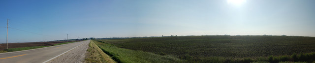
~9:30 am Wed May 18, R Ave, Dallas Center, IA 50063 .. GPS 41.663506, -93.960170. The Above Photograph, Is Composed Of 6 Photos That Form A ~180 degree Panoramic View Of The Farm Land, Along The Main County Road, About 3 Miles South Of Dallas Center IA.
.This panorama shows the area around the camera, FROM 1) Views of Fields Northwest TO 2) Straight North Along A Main Well Paved County Road (R Ave.), With Dallas Center IA, Seen In Distance: TO A View of Fields To The Southeast:
.(( Be sure to click the photo several times to its largest size. Then use the Click & Drag Scroll Bars, to move the photo Left or Right on your computer screen.))
Further Notes About Typical Iowa Flat & Treeless Landscape (As Seen In Above Photo)
VERSUS
Hills & Lots of Hardwood Trees In => The Artist's Conception Of The Ideal Iowa Farmstead (As Seen In Previous Photo):
. The lush forest of green leafy hardwoods, seen in the Previous Photo of The Ideal Iowa Farmstead, would actually have been relatively rare in Iowa, as the relatively dry climate causes, prevents naturally seeded trees from growing, except primarily near water, such as near rivers & streams. Or near homes, where purposely planted and watered until deep enough roots are grown by the tree, enough to live through the hot dry simmers.
.Also the relatively hilly landscape of this farmstead, would actually have been relatively rare in Iowa, which with exception of rivers & streams if relatively flat. This is seen in Henry Gurrs Above Panorama, as well as his other forthcoming photos of Sarah Vinkes Childhood Farm & Nearby Hometown, of Dallas Center IA..
.Wikipedia says => Iowa's natural vegetation is tallgrass prairie and savanna in upland areas, with dense forest and wetlands in flood plains and protected river valleys, and pothole wetlands in northern prairie areas.
.A Second Wikipedia Amplifies => Once past the extreme eastern portion of Iowa, settlers quickly discovered that the state was primarily a prairie or tall grass region. Trees grew abundantly [only] in the extreme eastern and southeastern portions, and [only] along rivers and streams, but elsewhere timber was limited.
Continued next photo. Photo File = DSC_0041 thru -0046.JPG Stitched By FlatWorld.com July31, 2020 = 12.jpg
Posted 5 Aug 2020.